You are here: Home > Network List > UW - Pacific Northwest Regional Seismic Network Stations List
> Station LUMI Lummi Island, WA > Earthquake Result Viewer
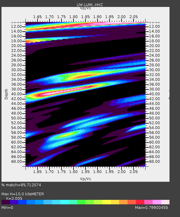
LUMI Lummi Island, WA - Earthquake Result Viewer
| Earthquake location: |
Near West Coast Of Honshu, Japan |
| Earthquake latitude/longitude: |
37.5/137.2 |
| Earthquake time(UTC): |
2024/01/01 (001) 07:10:10 GMT |
| Earthquake Depth: |
0.0 km |
| Earthquake Magnitude: |
7.4 Mi |
| Earthquake Catalog/Contributor: |
NEIC PDE/pt |
|
| Network: |
UW Pacific Northwest Regional Seismic Network |
| Station: |
LUMI Lummi Island, WA |
| Lat/Lon: |
48.72 N/122.71 W |
| Elevation: |
19 m |
|
| Distance: |
68.8 deg |
| Az: |
44.379 deg |
| Baz: |
302.865 deg |
| Ray Param: |
0.056105383 |
| Estimated Moho Depth: |
10.0 km |
| Estimated Crust Vp/Vs: |
2.01 |
| Assumed Crust Vp: |
6.566 km/s |
| Estimated Crust Vs: |
3.275 km/s |
| Estimated Crust Poisson's Ratio: |
0.33 |
|
| Radial Match: |
95.712074 % |
| Radial Bump: |
400 |
| Transverse Match: |
90.95378 % |
| Transverse Bump: |
400 |
| SOD ConfigId: |
33437571 |
| Insert Time: |
2024-01-15 08:15:03.914 +0000 |
| GWidth: |
2.5 |
| Max Bumps: |
400 |
| Tol: |
0.001 |
|

Signal To Noise
| Channel | StoN | STA | LTA |
| UW:LUMI: :HHZ:20240101T07:20:44.559998Z | 2.9877963 | 1.400447E-6 | 4.687224E-7 |
| UW:LUMI: :HHN:20240101T07:20:44.559998Z | 1.2901616 | 4.366252E-7 | 3.3842676E-7 |
| UW:LUMI: :HHE:20240101T07:20:44.559998Z | 1.3278259 | 7.003803E-7 | 5.2746395E-7 |
| Arrivals |
| Ps | 1.6 SECOND |
| PpPs | 4.4 SECOND |
| PsPs/PpSs | 6.0 SECOND |


