You are here: Home > Network List > UW - Pacific Northwest Regional Seismic Network Stations List
> Station RVSD Chattaroy, WA, USA > Earthquake Result Viewer
RVSD Chattaroy, WA, USA - Earthquake Result Viewer
| Earthquake location: |
Near West Coast Of Honshu, Japan |
| Earthquake latitude/longitude: |
37.5/137.2 |
| Earthquake time(UTC): |
2024/01/01 (001) 07:10:10 GMT |
| Earthquake Depth: |
0.0 km |
| Earthquake Magnitude: |
7.4 Mi |
| Earthquake Catalog/Contributor: |
NEIC PDE/pt |
|
| Network: |
UW Pacific Northwest Regional Seismic Network |
| Station: |
RVSD Chattaroy, WA, USA |
| Lat/Lon: |
47.96 N/117.36 W |
| Elevation: |
611 m |
|
| Distance: |
72.1 deg |
| Az: |
42.888 deg |
| Baz: |
306.353 deg |
| Ray Param: |
0.05388046 |
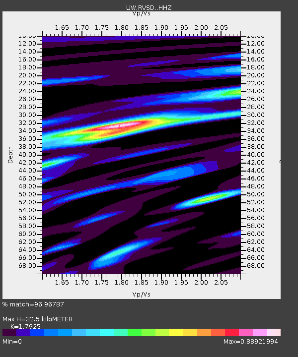
| Estimated Moho Depth: |
32.5 km |
| Estimated Crust Vp/Vs: |
1.79 |
| Assumed Crust Vp: |
6.571 km/s |
| Estimated Crust Vs: |
3.666 km/s |
| Estimated Crust Poisson's Ratio: |
0.27 |
|
| Radial Match: |
96.96787 % |
| Radial Bump: |
400 |
| Transverse Match: |
92.58279 % |
| Transverse Bump: |
400 |
| SOD ConfigId: |
33437571 |
| Insert Time: |
2024-01-15 08:15:54.573 +0000 |
| GWidth: |
2.5 |
| Max Bumps: |
400 |
| Tol: |
0.001 |
|

Signal To Noise
| Channel | StoN | STA | LTA |
| UW:RVSD: :HHZ:20240101T07:21:05.070007Z | 5.6484146 | 1.2412526E-6 | 2.1975238E-7 |
| UW:RVSD: :HHN:20240101T07:21:05.070007Z | 1.1335114 | 2.313619E-7 | 2.0411078E-7 |
| UW:RVSD: :HHE:20240101T07:21:05.070007Z | 1.0582882 | 3.0838075E-7 | 2.9139582E-7 |
| Arrivals |
| Ps | 4.1 SECOND |
| PpPs | 13 SECOND |
| PsPs/PpSs | 17 SECOND |


