You are here: Home > Network List > UW - Pacific Northwest Regional Seismic Network Stations List
> Station SEAS2 Gearhart, OR, USA > Earthquake Result Viewer
SEAS2 Gearhart, OR, USA - Earthquake Result Viewer
| Earthquake location: |
Near West Coast Of Honshu, Japan |
| Earthquake latitude/longitude: |
37.5/137.2 |
| Earthquake time(UTC): |
2024/01/01 (001) 07:10:10 GMT |
| Earthquake Depth: |
0.0 km |
| Earthquake Magnitude: |
7.4 Mi |
| Earthquake Catalog/Contributor: |
NEIC PDE/pt |
|
| Network: |
UW Pacific Northwest Regional Seismic Network |
| Station: |
SEAS2 Gearhart, OR, USA |
| Lat/Lon: |
46.04 N/123.90 W |
| Elevation: |
59 m |
|
| Distance: |
69.6 deg |
| Az: |
47.26 deg |
| Baz: |
303.017 deg |
| Ray Param: |
0.055584308 |
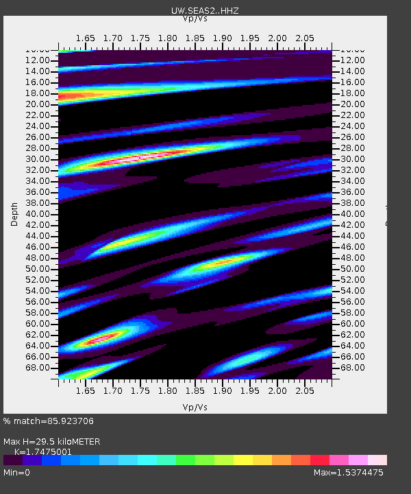
| Estimated Moho Depth: |
29.5 km |
| Estimated Crust Vp/Vs: |
1.75 |
| Assumed Crust Vp: |
6.566 km/s |
| Estimated Crust Vs: |
3.757 km/s |
| Estimated Crust Poisson's Ratio: |
0.26 |
|
| Radial Match: |
85.923706 % |
| Radial Bump: |
400 |
| Transverse Match: |
85.19229 % |
| Transverse Bump: |
400 |
| SOD ConfigId: |
33437571 |
| Insert Time: |
2024-01-15 08:16:01.057 +0000 |
| GWidth: |
2.5 |
| Max Bumps: |
400 |
| Tol: |
0.001 |
|

Signal To Noise
| Channel | StoN | STA | LTA |
| UW:SEAS2: :HHZ:20240101T07:20:49.400024Z | 2.3647518 | 2.0898274E-6 | 8.837407E-7 |
| UW:SEAS2: :HHN:20240101T07:20:49.400024Z | 1.0195097 | 1.792509E-6 | 1.758207E-6 |
| UW:SEAS2: :HHE:20240101T07:20:49.400024Z | 1.336441 | 1.922981E-6 | 1.4388821E-6 |
| Arrivals |
| Ps | 3.5 SECOND |
| PpPs | 12 SECOND |
| PsPs/PpSs | 15 SECOND |


