You are here: Home > Network List > UW - Pacific Northwest Regional Seismic Network Stations List
> Station TOLT Tolt Res, WA old TA-C05A > Earthquake Result Viewer
TOLT Tolt Res, WA old TA-C05A - Earthquake Result Viewer
| Earthquake location: |
Near West Coast Of Honshu, Japan |
| Earthquake latitude/longitude: |
37.5/137.2 |
| Earthquake time(UTC): |
2024/01/01 (001) 07:10:10 GMT |
| Earthquake Depth: |
0.0 km |
| Earthquake Magnitude: |
7.4 Mi |
| Earthquake Catalog/Contributor: |
NEIC PDE/pt |
|
| Network: |
UW Pacific Northwest Regional Seismic Network |
| Station: |
TOLT Tolt Res, WA old TA-C05A |
| Lat/Lon: |
47.69 N/121.69 W |
| Elevation: |
541 m |
|
| Distance: |
69.9 deg |
| Az: |
44.895 deg |
| Baz: |
303.803 deg |
| Ray Param: |
0.055357564 |
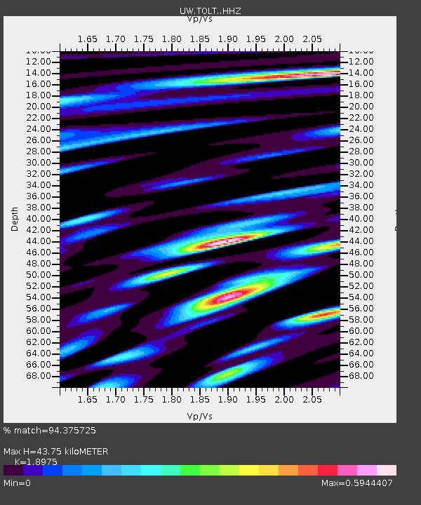
| Estimated Moho Depth: |
43.75 km |
| Estimated Crust Vp/Vs: |
1.90 |
| Assumed Crust Vp: |
6.597 km/s |
| Estimated Crust Vs: |
3.477 km/s |
| Estimated Crust Poisson's Ratio: |
0.31 |
|
| Radial Match: |
94.375725 % |
| Radial Bump: |
400 |
| Transverse Match: |
87.28404 % |
| Transverse Bump: |
400 |
| SOD ConfigId: |
33437571 |
| Insert Time: |
2024-01-15 08:16:29.485 +0000 |
| GWidth: |
2.5 |
| Max Bumps: |
400 |
| Tol: |
0.001 |
|

Signal To Noise
| Channel | StoN | STA | LTA |
| UW:TOLT: :HHZ:20240101T07:20:51.549988Z | 5.2656956 | 1.1602638E-6 | 2.2034388E-7 |
| UW:TOLT: :HHN:20240101T07:20:51.549988Z | 2.4715333 | 6.5145724E-7 | 2.6358424E-7 |
| UW:TOLT: :HHE:20240101T07:20:51.549988Z | 3.1078043 | 6.129012E-7 | 1.9721358E-7 |
| Arrivals |
| Ps | 6.2 SECOND |
| PpPs | 19 SECOND |
| PsPs/PpSs | 25 SECOND |


