You are here: Home > Network List > UW - Pacific Northwest Regional Seismic Network Stations List
> Station MBW2 Mt Baker West 2, WA, USA > Earthquake Result Viewer
MBW2 Mt Baker West 2, WA, USA - Earthquake Result Viewer
| Earthquake location: |
Near West Coast Of Honshu, Japan |
| Earthquake latitude/longitude: |
37.5/137.2 |
| Earthquake time(UTC): |
2024/01/01 (001) 07:10:10 GMT |
| Earthquake Depth: |
0.0 km |
| Earthquake Magnitude: |
7.4 Mi |
| Earthquake Catalog/Contributor: |
NEIC PDE/pt |
|
| Network: |
UW Pacific Northwest Regional Seismic Network |
| Station: |
MBW2 Mt Baker West 2, WA, USA |
| Lat/Lon: |
48.80 N/121.92 W |
| Elevation: |
1591 m |
|
| Distance: |
69.2 deg |
| Az: |
44.002 deg |
| Baz: |
303.32 deg |
| Ray Param: |
0.055843506 |
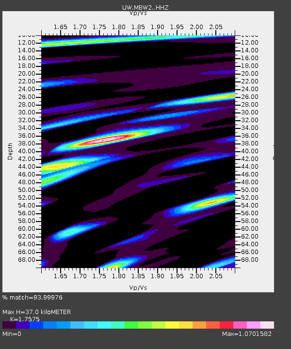
| Estimated Moho Depth: |
37.0 km |
| Estimated Crust Vp/Vs: |
1.76 |
| Assumed Crust Vp: |
6.566 km/s |
| Estimated Crust Vs: |
3.736 km/s |
| Estimated Crust Poisson's Ratio: |
0.26 |
|
| Radial Match: |
93.99976 % |
| Radial Bump: |
400 |
| Transverse Match: |
89.98933 % |
| Transverse Bump: |
400 |
| SOD ConfigId: |
33437571 |
| Insert Time: |
2024-01-15 08:17:13.443 +0000 |
| GWidth: |
2.5 |
| Max Bumps: |
400 |
| Tol: |
0.001 |
|

Signal To Noise
| Channel | StoN | STA | LTA |
| UW:MBW2: :HHZ:20240101T07:20:46.97998Z | 6.5223017 | 1.3244712E-6 | 2.0306808E-7 |
| UW:MBW2: :HHN:20240101T07:20:46.97998Z | 1.4496773 | 5.815648E-7 | 4.0116842E-7 |
| UW:MBW2: :HHE:20240101T07:20:46.97998Z | 1.6713091 | 5.3934446E-7 | 3.2270776E-7 |
| Arrivals |
| Ps | 4.4 SECOND |
| PpPs | 15 SECOND |
| PsPs/PpSs | 19 SECOND |


