You are here: Home > Network List > UW - Pacific Northwest Regional Seismic Network Stations List
> Station NCO Newberry Crater, OR, USA > Earthquake Result Viewer
NCO Newberry Crater, OR, USA - Earthquake Result Viewer
| Earthquake location: |
Near West Coast Of Honshu, Japan |
| Earthquake latitude/longitude: |
37.5/137.2 |
| Earthquake time(UTC): |
2024/01/01 (001) 07:10:10 GMT |
| Earthquake Depth: |
0.0 km |
| Earthquake Magnitude: |
7.4 Mi |
| Earthquake Catalog/Contributor: |
NEIC PDE/pt |
|
| Network: |
UW Pacific Northwest Regional Seismic Network |
| Station: |
NCO Newberry Crater, OR, USA |
| Lat/Lon: |
43.70 N/121.14 W |
| Elevation: |
1959 m |
|
| Distance: |
72.5 deg |
| Az: |
48.138 deg |
| Baz: |
305.241 deg |
| Ray Param: |
0.053648163 |
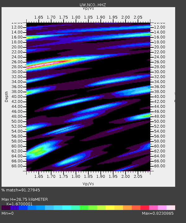
| Estimated Moho Depth: |
26.75 km |
| Estimated Crust Vp/Vs: |
1.67 |
| Assumed Crust Vp: |
6.597 km/s |
| Estimated Crust Vs: |
3.951 km/s |
| Estimated Crust Poisson's Ratio: |
0.22 |
|
| Radial Match: |
91.27945 % |
| Radial Bump: |
400 |
| Transverse Match: |
89.90032 % |
| Transverse Bump: |
400 |
| SOD ConfigId: |
33437571 |
| Insert Time: |
2024-01-15 08:17:20.633 +0000 |
| GWidth: |
2.5 |
| Max Bumps: |
400 |
| Tol: |
0.001 |
|

Signal To Noise
| Channel | StoN | STA | LTA |
| UW:NCO: :HHZ:20240101T07:21:07.130005Z | 6.084298 | 1.7336629E-6 | 2.8494048E-7 |
| UW:NCO: :HHN:20240101T07:21:07.130005Z | 1.3647301 | 5.02352E-7 | 3.680962E-7 |
| UW:NCO: :HHE:20240101T07:21:07.130005Z | 1.9964728 | 7.9078035E-7 | 3.960887E-7 |
| Arrivals |
| Ps | 2.8 SECOND |
| PpPs | 10 SECOND |
| PsPs/PpSs | 13 SECOND |


