You are here: Home > Network List > TA - USArray Transportable Network (new EarthScope stations) Stations List
> Station L04D Klamath Falls, OR, USA > Earthquake Result Viewer
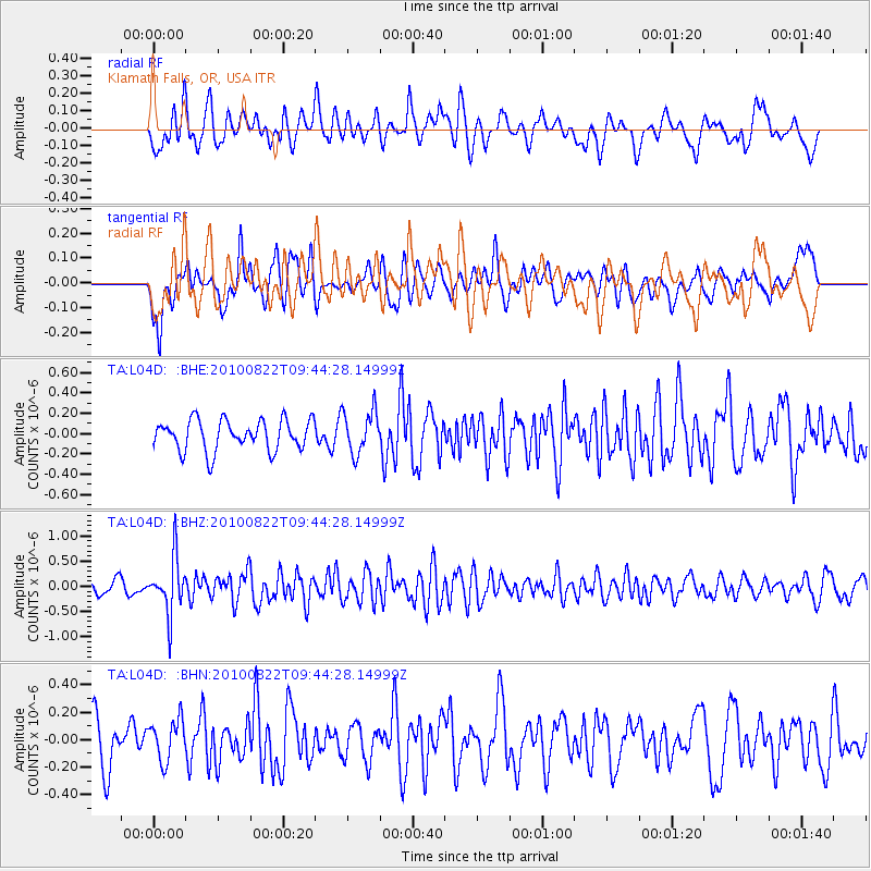
L04D Klamath Falls, OR, USA - Earthquake Result Viewer
*The percent match for this event was below the threshold and hence no stack was calculated.
| Earthquake location: |
Mariana Islands Region |
| Earthquake latitude/longitude: |
19.4/147.4 |
| Earthquake time(UTC): |
2010/08/22 (234) 09:33:06 GMT |
| Earthquake Depth: |
23 km |
| Earthquake Magnitude: |
5.9 MB, 5.3 MS, 5.5 MW |
| Earthquake Catalog/Contributor: |
WHDF/NEIC |
|
| Network: |
TA USArray Transportable Network (new EarthScope stations) |
| Station: |
L04D Klamath Falls, OR, USA |
| Lat/Lon: |
42.22 N/122.30 W |
| Elevation: |
1437 m |
|
| Distance: |
77.4 deg |
| Az: |
49.558 deg |
| Baz: |
284.796 deg |
| Ray Param: |
$rayparam |
*The percent match for this event was below the threshold and hence was not used in the summary stack. |
|
| Radial Match: |
66.067245 % |
| Radial Bump: |
400 |
| Transverse Match: |
45.45256 % |
| Transverse Bump: |
400 |
| SOD ConfigId: |
319893 |
| Insert Time: |
2011-01-06 01:44:34.941 +0000 |
| GWidth: |
2.5 |
| Max Bumps: |
400 |
| Tol: |
0.001 |
|
Signal To Noise
| Channel | StoN | STA | LTA |
| TA:L04D: :BHZ:20100822T09:44:28.14999Z | 4.796864 | 5.485693E-7 | 1.14359985E-7 |
| TA:L04D: :BHN:20100822T09:44:28.14999Z | 1.1957369 | 1.5158417E-7 | 1.2677052E-7 |
| TA:L04D: :BHE:20100822T09:44:28.14999Z | 1.4029032 | 2.1000308E-7 | 1.4969179E-7 |
| Arrivals |
| Ps | |
| PpPs | |
| PsPs/PpSs | |


