You are here: Home > Network List > TA - USArray Transportable Network (new EarthScope stations) Stations List
> Station O03D Paynes Creek, CA, USA > Earthquake Result Viewer
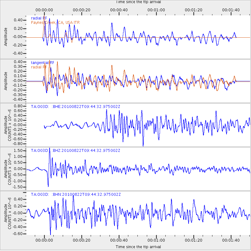
O03D Paynes Creek, CA, USA - Earthquake Result Viewer
*The percent match for this event was below the threshold and hence no stack was calculated.
| Earthquake location: |
Mariana Islands Region |
| Earthquake latitude/longitude: |
19.4/147.4 |
| Earthquake time(UTC): |
2010/08/22 (234) 09:33:06 GMT |
| Earthquake Depth: |
23 km |
| Earthquake Magnitude: |
5.9 MB, 5.3 MS, 5.5 MW |
| Earthquake Catalog/Contributor: |
WHDF/NEIC |
|
| Network: |
TA USArray Transportable Network (new EarthScope stations) |
| Station: |
O03D Paynes Creek, CA, USA |
| Lat/Lon: |
40.29 N/121.80 W |
| Elevation: |
968 m |
|
| Distance: |
78.3 deg |
| Az: |
51.354 deg |
| Baz: |
285.504 deg |
| Ray Param: |
$rayparam |
*The percent match for this event was below the threshold and hence was not used in the summary stack. |
|
| Radial Match: |
71.614365 % |
| Radial Bump: |
400 |
| Transverse Match: |
64.70186 % |
| Transverse Bump: |
400 |
| SOD ConfigId: |
319893 |
| Insert Time: |
2011-01-06 01:45:07.873 +0000 |
| GWidth: |
2.5 |
| Max Bumps: |
400 |
| Tol: |
0.001 |
|
Signal To Noise
| Channel | StoN | STA | LTA |
| TA:O03D: :BHZ:20100822T09:44:32.975002Z | 9.8311825 | 6.708854E-7 | 6.824056E-8 |
| TA:O03D: :BHN:20100822T09:44:32.975002Z | 1.8873855 | 1.8304823E-7 | 9.6985076E-8 |
| TA:O03D: :BHE:20100822T09:44:32.975002Z | 3.2202423 | 2.3527339E-7 | 7.306077E-8 |
| Arrivals |
| Ps | |
| PpPs | |
| PsPs/PpSs | |


