You are here: Home > Network List > N4 - Central and EAstern US Network Stations List
> Station L42A Oliver, Polo, IL, USA > Earthquake Result Viewer
L42A Oliver, Polo, IL, USA - Earthquake Result Viewer
| Earthquake location: |
Central Bolivia |
| Earthquake latitude/longitude: |
-17.9/-65.9 |
| Earthquake time(UTC): |
2019/03/15 (074) 05:03:50 GMT |
| Earthquake Depth: |
358 km |
| Earthquake Magnitude: |
6.3 Mww |
| Earthquake Catalog/Contributor: |
NEIC PDE/us |
|
| Network: |
N4 Central and EAstern US Network |
| Station: |
L42A Oliver, Polo, IL, USA |
| Lat/Lon: |
42.00 N/89.67 W |
| Elevation: |
257 m |
|
| Distance: |
63.5 deg |
| Az: |
340.379 deg |
| Baz: |
154.589 deg |
| Ray Param: |
0.05835105 |
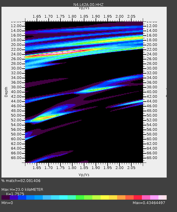
| Estimated Moho Depth: |
23.0 km |
| Estimated Crust Vp/Vs: |
1.76 |
| Assumed Crust Vp: |
6.571 km/s |
| Estimated Crust Vs: |
3.739 km/s |
| Estimated Crust Poisson's Ratio: |
0.26 |
|
| Radial Match: |
82.081406 % |
| Radial Bump: |
400 |
| Transverse Match: |
53.849873 % |
| Transverse Bump: |
400 |
| SOD ConfigId: |
3338192 |
| Insert Time: |
2019-03-29 05:22:44.337 +0000 |
| GWidth: |
2.5 |
| Max Bumps: |
400 |
| Tol: |
0.001 |
|

Signal To Noise
| Channel | StoN | STA | LTA |
| N4:L42A:00:HHZ:20190315T05:13:12.249983Z | 18.022623 | 2.0728767E-6 | 1.1501527E-7 |
| N4:L42A:00:HH1:20190315T05:13:12.249983Z | 5.987785 | 1.0920286E-6 | 1.8237607E-7 |
| N4:L42A:00:HH2:20190315T05:13:12.249983Z | 4.7093654 | 5.701855E-7 | 1.210748E-7 |
| Arrivals |
| Ps | 2.8 SECOND |
| PpPs | 9.2 SECOND |
| PsPs/PpSs | 12 SECOND |


