You are here: Home > Network List > N4 - Central and EAstern US Network Stations List
> Station M52A Chesterland, OH, USA > Earthquake Result Viewer
M52A Chesterland, OH, USA - Earthquake Result Viewer
| Earthquake location: |
Central Bolivia |
| Earthquake latitude/longitude: |
-17.9/-65.9 |
| Earthquake time(UTC): |
2019/03/15 (074) 05:03:50 GMT |
| Earthquake Depth: |
358 km |
| Earthquake Magnitude: |
6.3 Mww |
| Earthquake Catalog/Contributor: |
NEIC PDE/us |
|
| Network: |
N4 Central and EAstern US Network |
| Station: |
M52A Chesterland, OH, USA |
| Lat/Lon: |
41.54 N/81.36 W |
| Elevation: |
382 m |
|
| Distance: |
60.8 deg |
| Az: |
346.744 deg |
| Baz: |
163.087 deg |
| Ray Param: |
0.060046963 |
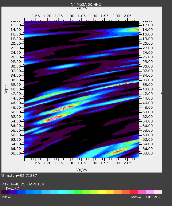
| Estimated Moho Depth: |
48.25 km |
| Estimated Crust Vp/Vs: |
1.77 |
| Assumed Crust Vp: |
6.483 km/s |
| Estimated Crust Vs: |
3.662 km/s |
| Estimated Crust Poisson's Ratio: |
0.27 |
|
| Radial Match: |
82.71387 % |
| Radial Bump: |
400 |
| Transverse Match: |
55.88201 % |
| Transverse Bump: |
400 |
| SOD ConfigId: |
3338192 |
| Insert Time: |
2019-03-29 05:22:53.033 +0000 |
| GWidth: |
2.5 |
| Max Bumps: |
400 |
| Tol: |
0.001 |
|

Signal To Noise
| Channel | StoN | STA | LTA |
| N4:M52A:00:HHZ:20190315T05:12:54.689985Z | 16.51528 | 2.1278702E-6 | 1.2884252E-7 |
| N4:M52A:00:HH1:20190315T05:12:54.689985Z | 5.381779 | 1.3992571E-6 | 2.5999898E-7 |
| N4:M52A:00:HH2:20190315T05:12:54.689985Z | 1.6316693 | 4.9060134E-7 | 3.006745E-7 |
| Arrivals |
| Ps | 6.0 SECOND |
| PpPs | 20 SECOND |
| PsPs/PpSs | 26 SECOND |


