You are here: Home > Network List > CI - Caltech Regional Seismic Network Stations List
> Station TIN Tinemaha, Big Pine, CA, USA > Earthquake Result Viewer
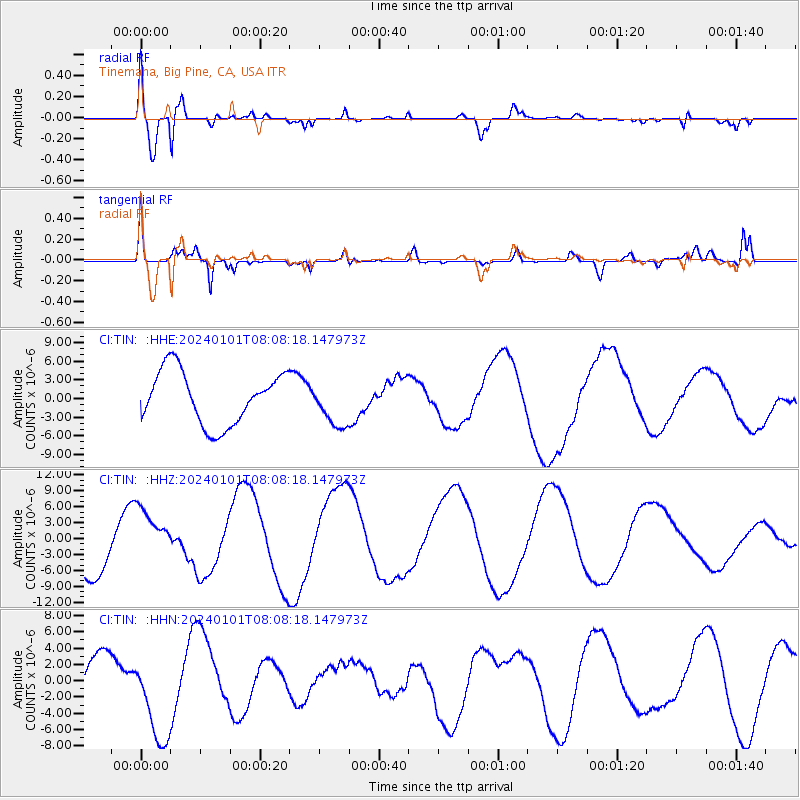
TIN Tinemaha, Big Pine, CA, USA - Earthquake Result Viewer
*The percent match for this event was below the threshold and hence no stack was calculated.
| Earthquake location: |
Near West Coast Of Honshu, Japan |
| Earthquake latitude/longitude: |
37.3/136.9 |
| Earthquake time(UTC): |
2024/01/01 (001) 07:56:48 GMT |
| Earthquake Depth: |
10 km |
| Earthquake Magnitude: |
5.6 Mww |
| Earthquake Catalog/Contributor: |
NEIC PDE/us |
|
| Network: |
CI Caltech Regional Seismic Network |
| Station: |
TIN Tinemaha, Big Pine, CA, USA |
| Lat/Lon: |
37.05 N/118.23 W |
| Elevation: |
1197 m |
|
| Distance: |
78.5 deg |
| Az: |
52.104 deg |
| Baz: |
308.129 deg |
| Ray Param: |
$rayparam |
*The percent match for this event was below the threshold and hence was not used in the summary stack. |
|
| Radial Match: |
83.88213 % |
| Radial Bump: |
400 |
| Transverse Match: |
59.79565 % |
| Transverse Bump: |
339 |
| SOD ConfigId: |
33437571 |
| Insert Time: |
2024-01-15 08:53:31.946 +0000 |
| GWidth: |
2.5 |
| Max Bumps: |
400 |
| Tol: |
0.001 |
|
Signal To Noise
| Channel | StoN | STA | LTA |
| CI:TIN: :HHZ:20240101T08:08:18.147973Z | 0.8391883 | 5.4692614E-6 | 6.5173235E-6 |
| CI:TIN: :HHN:20240101T08:08:18.147973Z | 1.7678338 | 6.0272814E-6 | 3.4094164E-6 |
| CI:TIN: :HHE:20240101T08:08:18.147973Z | 0.86336714 | 3.6509462E-6 | 4.2287297E-6 |
| Arrivals |
| Ps | |
| PpPs | |
| PsPs/PpSs | |


