You are here: Home > Network List > US - United States National Seismic Network Stations List
> Station MSO Missoula, Montana, USA > Earthquake Result Viewer
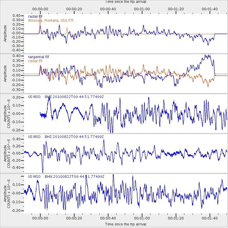
MSO Missoula, Montana, USA - Earthquake Result Viewer
*The percent match for this event was below the threshold and hence no stack was calculated.
| Earthquake location: |
Mariana Islands Region |
| Earthquake latitude/longitude: |
19.4/147.4 |
| Earthquake time(UTC): |
2010/08/22 (234) 09:33:06 GMT |
| Earthquake Depth: |
23 km |
| Earthquake Magnitude: |
5.9 MB, 5.3 MS, 5.5 MW |
| Earthquake Catalog/Contributor: |
WHDF/NEIC |
|
| Network: |
US United States National Seismic Network |
| Station: |
MSO Missoula, Montana, USA |
| Lat/Lon: |
46.83 N/113.94 W |
| Elevation: |
1264 m |
|
| Distance: |
81.8 deg |
| Az: |
43.296 deg |
| Baz: |
289.52 deg |
| Ray Param: |
$rayparam |
*The percent match for this event was below the threshold and hence was not used in the summary stack. |
|
| Radial Match: |
51.0648 % |
| Radial Bump: |
400 |
| Transverse Match: |
45.00631 % |
| Transverse Bump: |
400 |
| SOD ConfigId: |
319893 |
| Insert Time: |
2011-01-06 01:47:50.437 +0000 |
| GWidth: |
2.5 |
| Max Bumps: |
400 |
| Tol: |
0.001 |
|
Signal To Noise
| Channel | StoN | STA | LTA |
| US:MSO: :BHZ:20100822T09:44:51.77499Z | 4.009904 | 2.0354217E-7 | 5.0759866E-8 |
| US:MSO: :BHN:20100822T09:44:51.77499Z | 2.1529984 | 8.9724374E-8 | 4.167415E-8 |
| US:MSO: :BHE:20100822T09:44:51.77499Z | 1.5945199 | 9.630619E-8 | 6.0398236E-8 |
| Arrivals |
| Ps | |
| PpPs | |
| PsPs/PpSs | |


