You are here: Home > Network List > UW - Pacific Northwest Regional Seismic Network Stations List
> Station LEBA Lebam, WA, USA > Earthquake Result Viewer
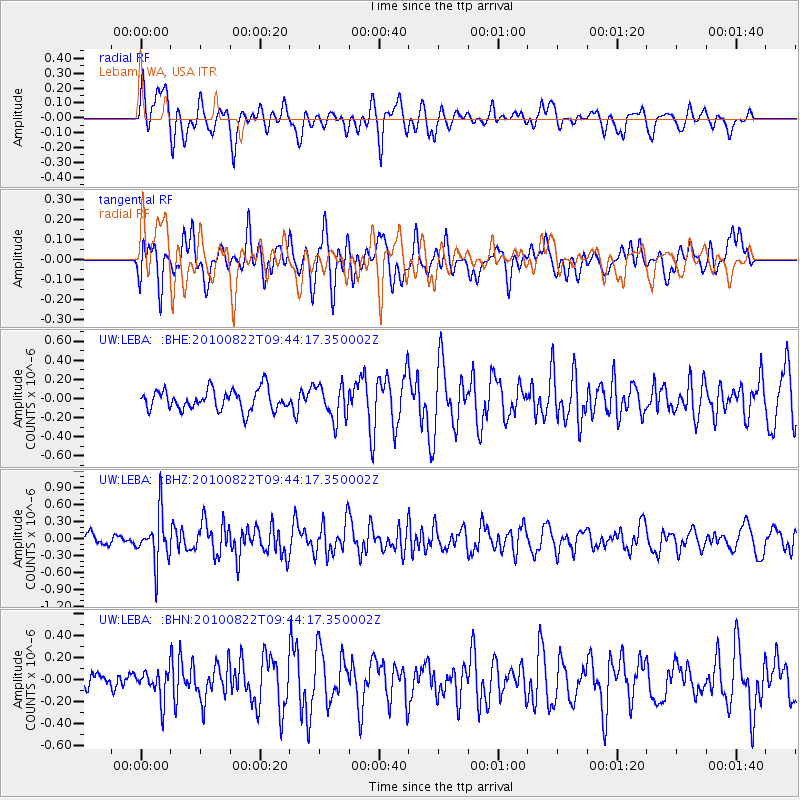
LEBA Lebam, WA, USA - Earthquake Result Viewer
*The percent match for this event was below the threshold and hence no stack was calculated.
| Earthquake location: |
Mariana Islands Region |
| Earthquake latitude/longitude: |
19.4/147.4 |
| Earthquake time(UTC): |
2010/08/22 (234) 09:33:06 GMT |
| Earthquake Depth: |
23 km |
| Earthquake Magnitude: |
5.9 MB, 5.3 MS, 5.5 MW |
| Earthquake Catalog/Contributor: |
WHDF/NEIC |
|
| Network: |
UW Pacific Northwest Regional Seismic Network |
| Station: |
LEBA Lebam, WA, USA |
| Lat/Lon: |
46.55 N/123.56 W |
| Elevation: |
73 m |
|
| Distance: |
75.5 deg |
| Az: |
45.46 deg |
| Baz: |
282.959 deg |
| Ray Param: |
$rayparam |
*The percent match for this event was below the threshold and hence was not used in the summary stack. |
|
| Radial Match: |
62.842117 % |
| Radial Bump: |
400 |
| Transverse Match: |
58.464886 % |
| Transverse Bump: |
400 |
| SOD ConfigId: |
319893 |
| Insert Time: |
2011-01-06 01:50:02.488 +0000 |
| GWidth: |
2.5 |
| Max Bumps: |
400 |
| Tol: |
0.001 |
|
Signal To Noise
| Channel | StoN | STA | LTA |
| UW:LEBA: :BHZ:20100822T09:44:17.350002Z | 3.4062178 | 4.292957E-7 | 1.2603296E-7 |
| UW:LEBA: :BHN:20100822T09:44:17.350002Z | 1.426437 | 1.3258463E-7 | 9.294811E-8 |
| UW:LEBA: :BHE:20100822T09:44:17.350002Z | 1.6600695 | 1.7740349E-7 | 1.068651E-7 |
| Arrivals |
| Ps | |
| PpPs | |
| PsPs/PpSs | |


