You are here: Home > Network List > CI - Caltech Regional Seismic Network Stations List
> Station MPM Manuel Prospect Mine, California, USA > Earthquake Result Viewer
MPM Manuel Prospect Mine, California, USA - Earthquake Result Viewer
*The percent match for this event was below the threshold and hence no stack was calculated.
| Earthquake location: |
South Of Mariana Islands |
| Earthquake latitude/longitude: |
12.8/143.5 |
| Earthquake time(UTC): |
2010/08/23 (235) 01:08:09 GMT |
| Earthquake Depth: |
124 km |
| Earthquake Magnitude: |
5.6 MB, 5.5 MW |
| Earthquake Catalog/Contributor: |
WHDF/NEIC |
|
| Network: |
CI Caltech Regional Seismic Network |
| Station: |
MPM Manuel Prospect Mine, California, USA |
| Lat/Lon: |
36.06 N/117.49 W |
| Elevation: |
185 m |
|
| Distance: |
89.7 deg |
| Az: |
53.169 deg |
| Baz: |
285.519 deg |
| Ray Param: |
$rayparam |
*The percent match for this event was below the threshold and hence was not used in the summary stack. |
|
| Radial Match: |
58.825752 % |
| Radial Bump: |
400 |
| Transverse Match: |
81.52479 % |
| Transverse Bump: |
400 |
| SOD ConfigId: |
319893 |
| Insert Time: |
2011-01-06 01:57:27.235 +0000 |
| GWidth: |
2.5 |
| Max Bumps: |
400 |
| Tol: |
0.001 |
|
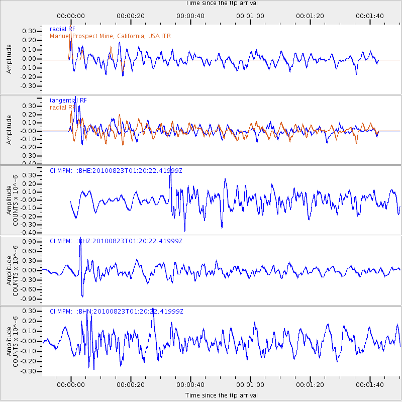
Signal To Noise
| Channel | StoN | STA | LTA |
| CI:MPM: :BHZ:20100823T01:20:22.41999Z | 7.505786 | 3.7705263E-7 | 5.023493E-8 |
| CI:MPM: :BHN:20100823T01:20:22.41999Z | 1.6870956 | 8.8730296E-8 | 5.2593517E-8 |
| CI:MPM: :BHE:20100823T01:20:22.41999Z | 1.8078994 | 1.3772262E-7 | 7.617826E-8 |
| Arrivals |
| Ps | |
| PpPs | |
| PsPs/PpSs | |


