You are here: Home > Network List > TX - Texas Seismological Network Stations List
> Station PB06 Permian Basin 6 > Earthquake Result Viewer
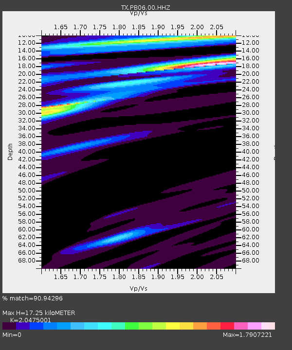
PB06 Permian Basin 6 - Earthquake Result Viewer
| Earthquake location: |
La Rioja Province, Argentina |
| Earthquake latitude/longitude: |
-28.5/-68.9 |
| Earthquake time(UTC): |
2024/01/03 (003) 08:04:01 GMT |
| Earthquake Depth: |
155 km |
| Earthquake Magnitude: |
5.5 mww |
| Earthquake Catalog/Contributor: |
NEIC PDE/us |
|
| Network: |
TX Texas Seismological Network |
| Station: |
PB06 Permian Basin 6 |
| Lat/Lon: |
31.65 N/103.22 W |
| Elevation: |
831 m |
|
| Distance: |
68.1 deg |
| Az: |
328.823 deg |
| Baz: |
147.692 deg |
| Ray Param: |
0.0561107 |
| Estimated Moho Depth: |
17.25 km |
| Estimated Crust Vp/Vs: |
2.05 |
| Assumed Crust Vp: |
6.121 km/s |
| Estimated Crust Vs: |
2.989 km/s |
| Estimated Crust Poisson's Ratio: |
0.34 |
|
| Radial Match: |
90.94296 % |
| Radial Bump: |
368 |
| Transverse Match: |
50.34358 % |
| Transverse Bump: |
400 |
| SOD ConfigId: |
33437571 |
| Insert Time: |
2024-01-17 08:23:53.694 +0000 |
| GWidth: |
2.5 |
| Max Bumps: |
400 |
| Tol: |
0.001 |
|

Signal To Noise
| Channel | StoN | STA | LTA |
| TX:PB06:00:HHZ:20240103T08:14:13.959976Z | 0.9248754 | 6.7821924E-7 | 7.3330875E-7 |
| TX:PB06:00:HH1:20240103T08:14:13.959976Z | 1.1627086 | 1.001274E-6 | 8.611564E-7 |
| TX:PB06:00:HH2:20240103T08:14:13.959976Z | 0.87276477 | 4.826375E-7 | 5.5299836E-7 |
| Arrivals |
| Ps | 3.0 SECOND |
| PpPs | 8.3 SECOND |
| PsPs/PpSs | 11 SECOND |


