You are here: Home > Network List > TA - USArray Transportable Network (new EarthScope stations) Stations List
> Station J19A Crowheart, WY, USA > Earthquake Result Viewer
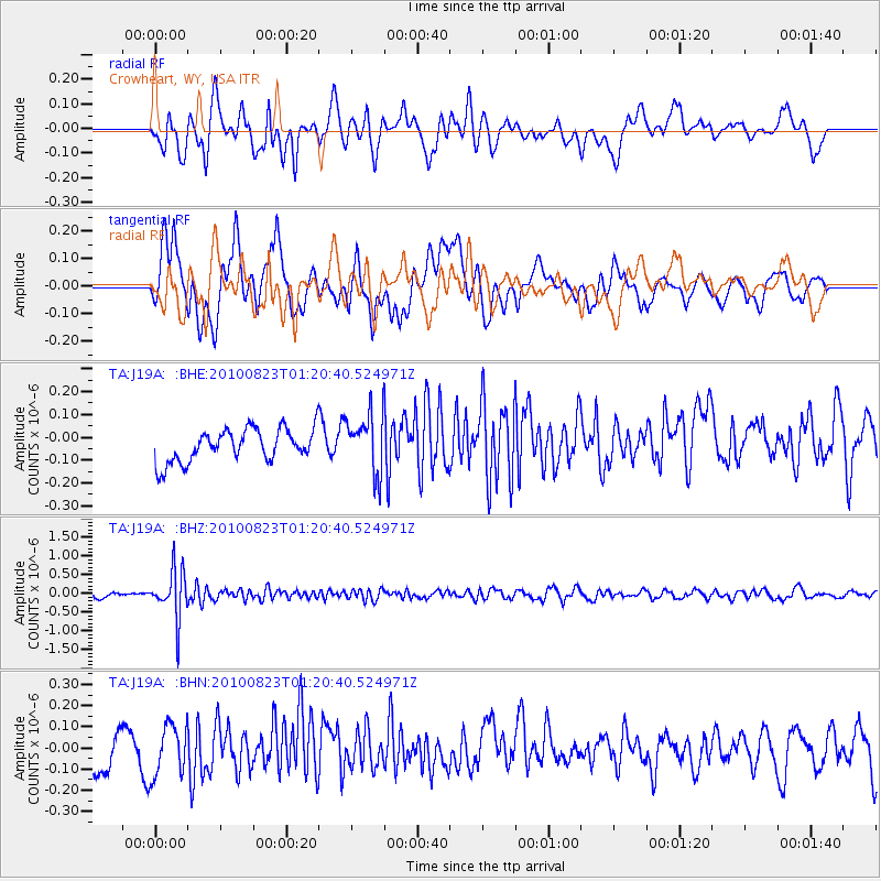
J19A Crowheart, WY, USA - Earthquake Result Viewer
*The percent match for this event was below the threshold and hence no stack was calculated.
| Earthquake location: |
South Of Mariana Islands |
| Earthquake latitude/longitude: |
12.8/143.5 |
| Earthquake time(UTC): |
2010/08/23 (235) 01:08:09 GMT |
| Earthquake Depth: |
124 km |
| Earthquake Magnitude: |
5.6 MB, 5.5 MW |
| Earthquake Catalog/Contributor: |
WHDF/NEIC |
|
| Network: |
TA USArray Transportable Network (new EarthScope stations) |
| Station: |
J19A Crowheart, WY, USA |
| Lat/Lon: |
43.26 N/109.05 W |
| Elevation: |
1782 m |
|
| Distance: |
93.6 deg |
| Az: |
44.301 deg |
| Baz: |
291.151 deg |
| Ray Param: |
$rayparam |
*The percent match for this event was below the threshold and hence was not used in the summary stack. |
|
| Radial Match: |
62.99906 % |
| Radial Bump: |
400 |
| Transverse Match: |
61.299824 % |
| Transverse Bump: |
400 |
| SOD ConfigId: |
319893 |
| Insert Time: |
2011-01-06 02:04:33.674 +0000 |
| GWidth: |
2.5 |
| Max Bumps: |
400 |
| Tol: |
0.001 |
|
Signal To Noise
| Channel | StoN | STA | LTA |
| TA:J19A: :BHZ:20100823T01:20:40.524971Z | 6.900761 | 6.471717E-7 | 9.378265E-8 |
| TA:J19A: :BHN:20100823T01:20:40.524971Z | 1.4465535 | 1.210277E-7 | 8.366624E-8 |
| TA:J19A: :BHE:20100823T01:20:40.524971Z | 1.8269379 | 1.3042947E-7 | 7.139239E-8 |
| Arrivals |
| Ps | |
| PpPs | |
| PsPs/PpSs | |


