You are here: Home > Network List > TA - USArray Transportable Network (new EarthScope stations) Stations List
> Station H19A Powell, WY, USA > Earthquake Result Viewer
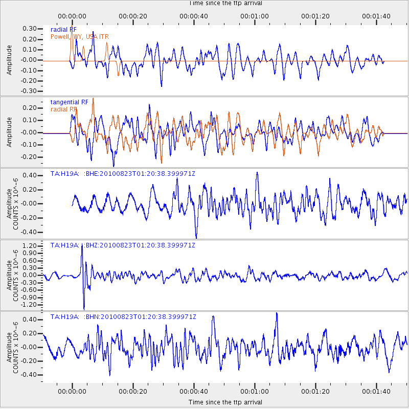
H19A Powell, WY, USA - Earthquake Result Viewer
*The percent match for this event was below the threshold and hence no stack was calculated.
| Earthquake location: |
South Of Mariana Islands |
| Earthquake latitude/longitude: |
12.8/143.5 |
| Earthquake time(UTC): |
2010/08/23 (235) 01:08:09 GMT |
| Earthquake Depth: |
124 km |
| Earthquake Magnitude: |
5.6 MB, 5.5 MW |
| Earthquake Catalog/Contributor: |
WHDF/NEIC |
|
| Network: |
TA USArray Transportable Network (new EarthScope stations) |
| Station: |
H19A Powell, WY, USA |
| Lat/Lon: |
44.67 N/108.99 W |
| Elevation: |
1479 m |
|
| Distance: |
93.1 deg |
| Az: |
42.971 deg |
| Baz: |
291.275 deg |
| Ray Param: |
$rayparam |
*The percent match for this event was below the threshold and hence was not used in the summary stack. |
|
| Radial Match: |
58.969563 % |
| Radial Bump: |
400 |
| Transverse Match: |
67.31555 % |
| Transverse Bump: |
400 |
| SOD ConfigId: |
319893 |
| Insert Time: |
2011-01-06 02:04:51.483 +0000 |
| GWidth: |
2.5 |
| Max Bumps: |
400 |
| Tol: |
0.001 |
|
Signal To Noise
| Channel | StoN | STA | LTA |
| TA:H19A: :BHZ:20100823T01:20:38.399971Z | 5.8805714 | 4.958284E-7 | 8.431636E-8 |
| TA:H19A: :BHN:20100823T01:20:38.399971Z | 0.84762716 | 8.1752994E-8 | 9.6449234E-8 |
| TA:H19A: :BHE:20100823T01:20:38.399971Z | 1.6942868 | 1.4638776E-7 | 8.640081E-8 |
| Arrivals |
| Ps | |
| PpPs | |
| PsPs/PpSs | |


