You are here: Home > Network List > TM - Thai Seismic Monitoring Network Stations List
> Station MHIT Mueang, MaeHongSon > Earthquake Result Viewer
MHIT Mueang, MaeHongSon - Earthquake Result Viewer
| Earthquake location: |
Balleny Islands Region |
| Earthquake latitude/longitude: |
-62.3/165.3 |
| Earthquake time(UTC): |
2024/01/07 (007) 20:00:07 GMT |
| Earthquake Depth: |
10 km |
| Earthquake Magnitude: |
5.5 Mww |
| Earthquake Catalog/Contributor: |
NEIC PDE/us |
|
| Network: |
TM Thai Seismic Monitoring Network |
| Station: |
MHIT Mueang, MaeHongSon |
| Lat/Lon: |
19.31 N/97.96 E |
| Elevation: |
270 m |
|
| Distance: |
97.0 deg |
| Az: |
298.585 deg |
| Baz: |
154.275 deg |
| Ray Param: |
0.040364973 |
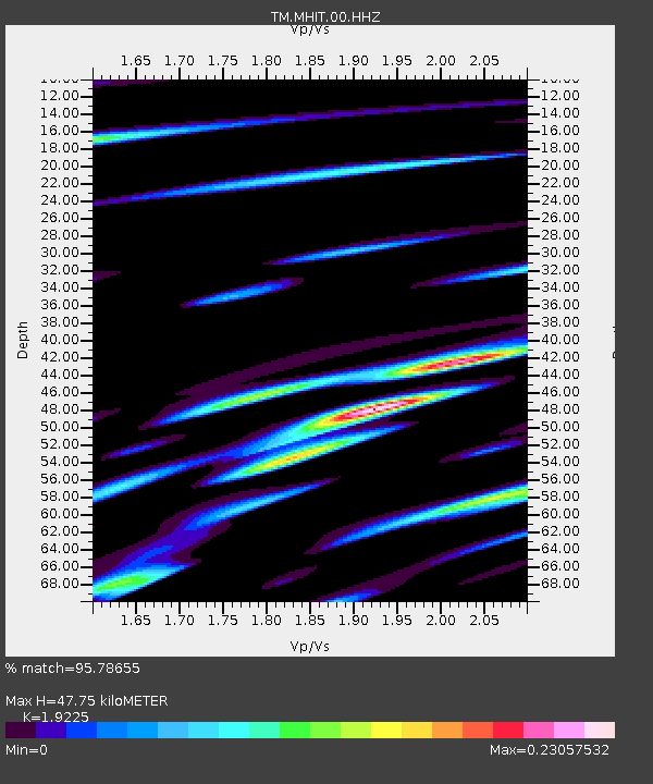
| Estimated Moho Depth: |
47.75 km |
| Estimated Crust Vp/Vs: |
1.92 |
| Assumed Crust Vp: |
6.316 km/s |
| Estimated Crust Vs: |
3.285 km/s |
| Estimated Crust Poisson's Ratio: |
0.31 |
|
| Radial Match: |
95.78655 % |
| Radial Bump: |
153 |
| Transverse Match: |
68.37777 % |
| Transverse Bump: |
400 |
| SOD ConfigId: |
33437571 |
| Insert Time: |
2024-01-21 20:04:59.756 +0000 |
| GWidth: |
2.5 |
| Max Bumps: |
400 |
| Tol: |
0.001 |
|

Signal To Noise
| Channel | StoN | STA | LTA |
| TM:MHIT:00:HHZ:20240107T20:13:07.120025Z | 1.4429349 | 1.9324979E-8 | 1.3392829E-8 |
| TM:MHIT:00:HHN:20240107T20:13:07.120025Z | 1.409979 | 1.8675461E-8 | 1.3245206E-8 |
| TM:MHIT:00:HHE:20240107T20:13:07.120025Z | 1.9104589 | 3.2548055E-8 | 1.7036772E-8 |
| Arrivals |
| Ps | 7.1 SECOND |
| PpPs | 22 SECOND |
| PsPs/PpSs | 29 SECOND |


