You are here: Home > Network List > AK - Alaska Regional Network Stations List
> Station D17K Noatak River, AK, USA > Earthquake Result Viewer
D17K Noatak River, AK, USA - Earthquake Result Viewer
| Earthquake location: |
Talaud Islands, Indonesia |
| Earthquake latitude/longitude: |
4.9/126.3 |
| Earthquake time(UTC): |
2024/01/08 (008) 20:48:46 GMT |
| Earthquake Depth: |
91 km |
| Earthquake Magnitude: |
7.0 Mi |
| Earthquake Catalog/Contributor: |
NEIC PDE/at |
|
| Network: |
AK Alaska Regional Network |
| Station: |
D17K Noatak River, AK, USA |
| Lat/Lon: |
67.70 N/163.08 W |
| Elevation: |
172 m |
|
| Distance: |
78.2 deg |
| Az: |
21.575 deg |
| Baz: |
253.751 deg |
| Ray Param: |
0.049589675 |
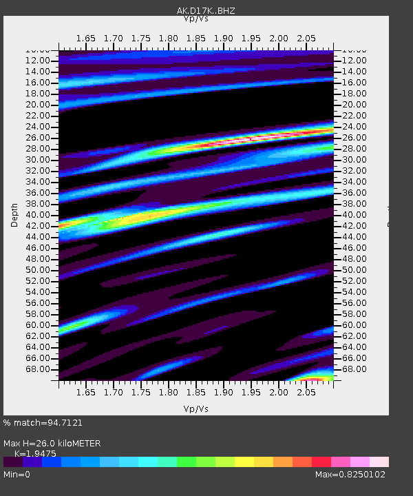
| Estimated Moho Depth: |
26.0 km |
| Estimated Crust Vp/Vs: |
1.95 |
| Assumed Crust Vp: |
6.276 km/s |
| Estimated Crust Vs: |
3.222 km/s |
| Estimated Crust Poisson's Ratio: |
0.32 |
|
| Radial Match: |
94.7121 % |
| Radial Bump: |
302 |
| Transverse Match: |
87.84114 % |
| Transverse Bump: |
400 |
| SOD ConfigId: |
33437571 |
| Insert Time: |
2024-01-22 20:52:27.695 +0000 |
| GWidth: |
2.5 |
| Max Bumps: |
400 |
| Tol: |
0.001 |
|

Signal To Noise
| Channel | StoN | STA | LTA |
| AK:D17K: :BHZ:20240108T21:00:04.659973Z | 8.7737055 | 1.9533693E-6 | 2.2263903E-7 |
| AK:D17K: :BHN:20240108T21:00:04.659973Z | 1.8221827 | 2.7939788E-7 | 1.5333144E-7 |
| AK:D17K: :BHE:20240108T21:00:04.659973Z | 4.2649364 | 7.834703E-7 | 1.8370034E-7 |
| Arrivals |
| Ps | 4.0 SECOND |
| PpPs | 12 SECOND |
| PsPs/PpSs | 16 SECOND |


