You are here: Home > Network List > AK - Alaska Regional Network Stations List
> Station H22K Ishtalitna Creek, AK, USA > Earthquake Result Viewer
H22K Ishtalitna Creek, AK, USA - Earthquake Result Viewer
| Earthquake location: |
Talaud Islands, Indonesia |
| Earthquake latitude/longitude: |
4.9/126.3 |
| Earthquake time(UTC): |
2024/01/08 (008) 20:48:46 GMT |
| Earthquake Depth: |
91 km |
| Earthquake Magnitude: |
7.0 Mi |
| Earthquake Catalog/Contributor: |
NEIC PDE/at |
|
| Network: |
AK Alaska Regional Network |
| Station: |
H22K Ishtalitna Creek, AK, USA |
| Lat/Lon: |
65.89 N/151.38 W |
| Elevation: |
561 m |
|
| Distance: |
82.4 deg |
| Az: |
24.242 deg |
| Baz: |
264.954 deg |
| Ray Param: |
0.04669937 |
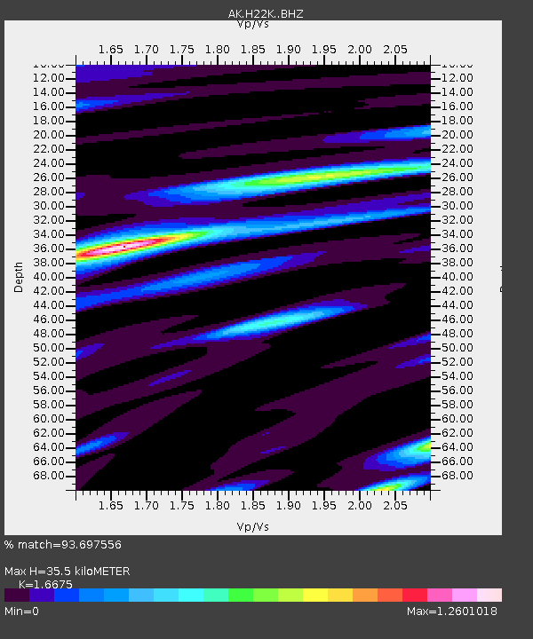
| Estimated Moho Depth: |
35.5 km |
| Estimated Crust Vp/Vs: |
1.67 |
| Assumed Crust Vp: |
6.566 km/s |
| Estimated Crust Vs: |
3.938 km/s |
| Estimated Crust Poisson's Ratio: |
0.22 |
|
| Radial Match: |
93.697556 % |
| Radial Bump: |
356 |
| Transverse Match: |
88.944756 % |
| Transverse Bump: |
400 |
| SOD ConfigId: |
33437571 |
| Insert Time: |
2024-01-22 20:53:14.564 +0000 |
| GWidth: |
2.5 |
| Max Bumps: |
400 |
| Tol: |
0.001 |
|

Signal To Noise
| Channel | StoN | STA | LTA |
| AK:H22K: :BHZ:20240108T21:00:27.179993Z | 10.951632 | 2.5862362E-6 | 2.3615075E-7 |
| AK:H22K: :BHN:20240108T21:00:27.179993Z | 0.40380403 | 9.969738E-8 | 2.4689547E-7 |
| AK:H22K: :BHE:20240108T21:00:27.179993Z | 4.2731495 | 7.605268E-7 | 1.7797807E-7 |
| Arrivals |
| Ps | 3.7 SECOND |
| PpPs | 14 SECOND |
| PsPs/PpSs | 18 SECOND |


