You are here: Home > Network List > TA - USArray Transportable Network (new EarthScope stations) Stations List
> Station N02D Trinity Center, CA, USA > Earthquake Result Viewer
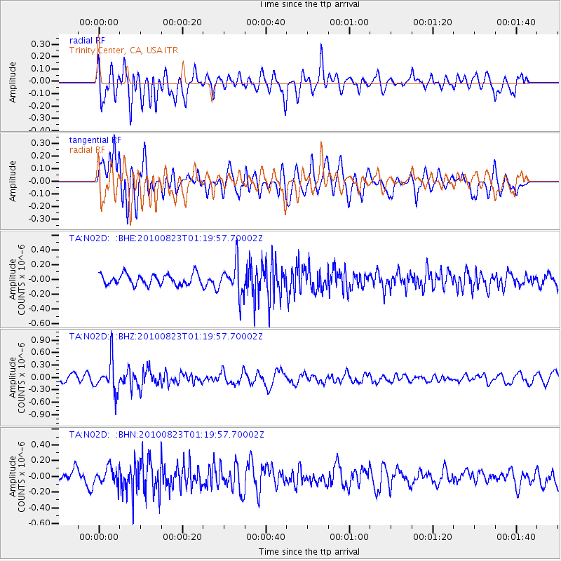
N02D Trinity Center, CA, USA - Earthquake Result Viewer
*The percent match for this event was below the threshold and hence no stack was calculated.
| Earthquake location: |
South Of Mariana Islands |
| Earthquake latitude/longitude: |
12.8/143.5 |
| Earthquake time(UTC): |
2010/08/23 (235) 01:08:09 GMT |
| Earthquake Depth: |
124 km |
| Earthquake Magnitude: |
5.6 MB, 5.5 MW |
| Earthquake Catalog/Contributor: |
WHDF/NEIC |
|
| Network: |
TA USArray Transportable Network (new EarthScope stations) |
| Station: |
N02D Trinity Center, CA, USA |
| Lat/Lon: |
40.97 N/122.71 W |
| Elevation: |
937 m |
|
| Distance: |
84.5 deg |
| Az: |
49.379 deg |
| Baz: |
282.087 deg |
| Ray Param: |
$rayparam |
*The percent match for this event was below the threshold and hence was not used in the summary stack. |
|
| Radial Match: |
71.752594 % |
| Radial Bump: |
400 |
| Transverse Match: |
64.08467 % |
| Transverse Bump: |
400 |
| SOD ConfigId: |
319893 |
| Insert Time: |
2011-01-06 02:08:45.500 +0000 |
| GWidth: |
2.5 |
| Max Bumps: |
400 |
| Tol: |
0.001 |
|
Signal To Noise
| Channel | StoN | STA | LTA |
| TA:N02D: :BHZ:20100823T01:19:57.70002Z | 3.938581 | 4.0220124E-7 | 1.02118314E-7 |
| TA:N02D: :BHN:20100823T01:19:57.70002Z | 1.1740488 | 1.0284834E-7 | 8.7601414E-8 |
| TA:N02D: :BHE:20100823T01:19:57.70002Z | 3.05071 | 2.183653E-7 | 7.157852E-8 |
| Arrivals |
| Ps | |
| PpPs | |
| PsPs/PpSs | |


