You are here: Home > Network List > AK - Alaska Regional Network Stations List
> Station O19K Port Alsworth, AK, USA > Earthquake Result Viewer
O19K Port Alsworth, AK, USA - Earthquake Result Viewer
| Earthquake location: |
Talaud Islands, Indonesia |
| Earthquake latitude/longitude: |
4.9/126.3 |
| Earthquake time(UTC): |
2024/01/08 (008) 20:48:46 GMT |
| Earthquake Depth: |
91 km |
| Earthquake Magnitude: |
7.0 Mi |
| Earthquake Catalog/Contributor: |
NEIC PDE/at |
|
| Network: |
AK Alaska Regional Network |
| Station: |
O19K Port Alsworth, AK, USA |
| Lat/Lon: |
60.20 N/154.32 W |
| Elevation: |
96 m |
|
| Distance: |
80.5 deg |
| Az: |
29.853 deg |
| Baz: |
263.164 deg |
| Ray Param: |
0.04803296 |
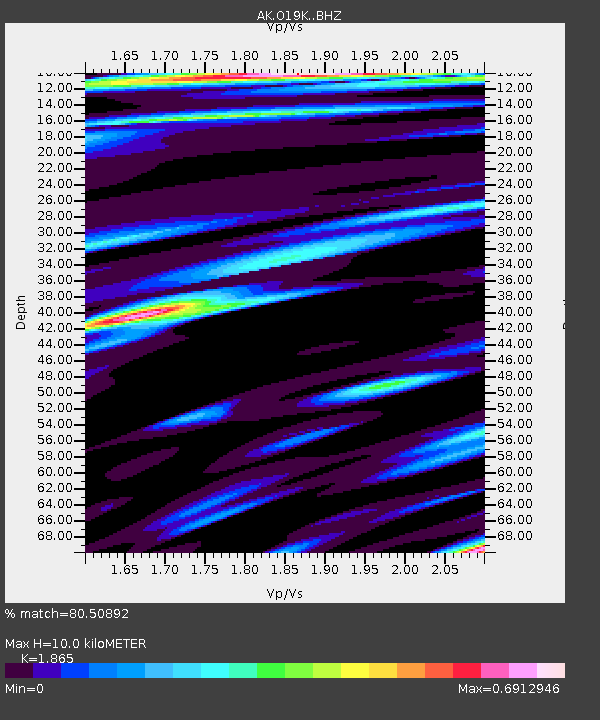
| Estimated Moho Depth: |
10.0 km |
| Estimated Crust Vp/Vs: |
1.87 |
| Assumed Crust Vp: |
6.566 km/s |
| Estimated Crust Vs: |
3.521 km/s |
| Estimated Crust Poisson's Ratio: |
0.30 |
|
| Radial Match: |
80.50892 % |
| Radial Bump: |
400 |
| Transverse Match: |
71.16187 % |
| Transverse Bump: |
400 |
| SOD ConfigId: |
33437571 |
| Insert Time: |
2024-01-22 20:54:21.789 +0000 |
| GWidth: |
2.5 |
| Max Bumps: |
400 |
| Tol: |
0.001 |
|

Signal To Noise
| Channel | StoN | STA | LTA |
| AK:O19K: :BHZ:20240108T21:00:17.059998Z | 4.882957 | 1.9202498E-6 | 3.9325553E-7 |
| AK:O19K: :BHN:20240108T21:00:17.059998Z | 0.87878764 | 3.4181267E-7 | 3.8895934E-7 |
| AK:O19K: :BHE:20240108T21:00:17.059998Z | 1.6656469 | 5.62034E-7 | 3.3742688E-7 |
| Arrivals |
| Ps | 1.4 SECOND |
| PpPs | 4.2 SECOND |
| PsPs/PpSs | 5.6 SECOND |


