You are here: Home > Network List > XG92 - Rocky Mountain Front Stations List
> Station BUR Burlington, CO > Earthquake Result Viewer
BUR Burlington, CO - Earthquake Result Viewer

| Earthquake location: |
Near Coast Of Nicaragua |
| Earthquake latitude/longitude: |
12.0/-87.3 |
| Earthquake time(UTC): |
1992/09/05 (249) 21:48:11 GMT |
| Earthquake Depth: |
10 km |
| Earthquake Magnitude: |
5.1 MB, 5.9 MS |
| Earthquake Catalog/Contributor: |
WHDF/NEIC |
|
| Network: |
XG Rocky Mountain Front |
| Station: |
BUR Burlington, CO |
| Lat/Lon: |
39.39 N/102.35 W |
| Elevation: |
1255 m |
|
| Distance: |
30.4 deg |
| Az: |
336.619 deg |
| Baz: |
149.927 deg |
| Ray Param: |
0.07934724 |
| Estimated Moho Depth: |
34.75 km |
| Estimated Crust Vp/Vs: |
1.66 |
| Assumed Crust Vp: |
6.242 km/s |
| Estimated Crust Vs: |
3.766 km/s |
| Estimated Crust Poisson's Ratio: |
0.21 |
|
| Radial Match: |
89.46083 % |
| Radial Bump: |
242 |
| Transverse Match: |
46.371597 % |
| Transverse Bump: |
398 |
| SOD ConfigId: |
3286 |
| Insert Time: |
2010-02-25 20:07:54.810 +0000 |
| GWidth: |
2.5 |
| Max Bumps: |
400 |
| Tol: |
0.001 |
|
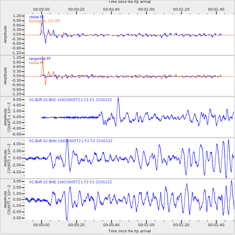
Signal To Noise
| Channel | StoN | STA | LTA |
| XG:BUR:02:BHN:19920905T21:53:53.320013Z | 2.707324 | 4.550337E-4 | 1.6807509E-4 |
| XG:BUR:02:BHE:19920905T21:53:53.320013Z | 1.7576265 | 3.0465392E-4 | 1.7333256E-4 |
| XG:BUR:02:BHZ:19920905T21:53:53.320013Z | 6.241507 | 7.540124E-4 | 1.20806144E-4 |
| Arrivals |
| Ps | 4.0 SECOND |
| PpPs | 14 SECOND |
| PsPs/PpSs | 18 SECOND |


