You are here: Home > Network List > US - United States National Seismic Network Stations List
> Station LAO LASA Array, Montana, USA > Earthquake Result Viewer
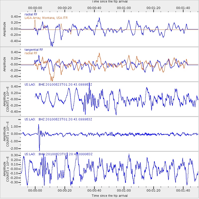
LAO LASA Array, Montana, USA - Earthquake Result Viewer
*The percent match for this event was below the threshold and hence no stack was calculated.
| Earthquake location: |
South Of Mariana Islands |
| Earthquake latitude/longitude: |
12.8/143.5 |
| Earthquake time(UTC): |
2010/08/23 (235) 01:08:09 GMT |
| Earthquake Depth: |
124 km |
| Earthquake Magnitude: |
5.6 MB, 5.5 MW |
| Earthquake Catalog/Contributor: |
WHDF/NEIC |
|
| Network: |
US United States National Seismic Network |
| Station: |
LAO LASA Array, Montana, USA |
| Lat/Lon: |
46.69 N/106.22 W |
| Elevation: |
902 m |
|
| Distance: |
94.2 deg |
| Az: |
40.363 deg |
| Baz: |
293.412 deg |
| Ray Param: |
$rayparam |
*The percent match for this event was below the threshold and hence was not used in the summary stack. |
|
| Radial Match: |
67.36823 % |
| Radial Bump: |
400 |
| Transverse Match: |
69.3541 % |
| Transverse Bump: |
400 |
| SOD ConfigId: |
319893 |
| Insert Time: |
2011-01-06 02:11:10.241 +0000 |
| GWidth: |
2.5 |
| Max Bumps: |
400 |
| Tol: |
0.001 |
|
Signal To Noise
| Channel | StoN | STA | LTA |
| US:LAO: :BHZ:20100823T01:20:43.099983Z | 6.472771 | 6.531821E-7 | 1.0091228E-7 |
| US:LAO: :BHN:20100823T01:20:43.099983Z | 0.7474974 | 9.736413E-8 | 1.3025347E-7 |
| US:LAO: :BHE:20100823T01:20:43.099983Z | 1.2433469 | 1.7936254E-7 | 1.4425784E-7 |
| Arrivals |
| Ps | |
| PpPs | |
| PsPs/PpSs | |


