You are here: Home > Network List > US - United States National Seismic Network Stations List
> Station EGMT Eagleton, Montana, USA > Earthquake Result Viewer
EGMT Eagleton, Montana, USA - Earthquake Result Viewer
*The percent match for this event was below the threshold and hence no stack was calculated.
| Earthquake location: |
South Of Mariana Islands |
| Earthquake latitude/longitude: |
12.8/143.5 |
| Earthquake time(UTC): |
2010/08/23 (235) 01:08:09 GMT |
| Earthquake Depth: |
124 km |
| Earthquake Magnitude: |
5.6 MB, 5.5 MW |
| Earthquake Catalog/Contributor: |
WHDF/NEIC |
|
| Network: |
US United States National Seismic Network |
| Station: |
EGMT Eagleton, Montana, USA |
| Lat/Lon: |
48.02 N/109.75 W |
| Elevation: |
1055 m |
|
| Distance: |
91.4 deg |
| Az: |
40.03 deg |
| Baz: |
290.837 deg |
| Ray Param: |
$rayparam |
*The percent match for this event was below the threshold and hence was not used in the summary stack. |
|
| Radial Match: |
40.69354 % |
| Radial Bump: |
400 |
| Transverse Match: |
44.461594 % |
| Transverse Bump: |
400 |
| SOD ConfigId: |
319893 |
| Insert Time: |
2011-01-06 02:11:22.034 +0000 |
| GWidth: |
2.5 |
| Max Bumps: |
400 |
| Tol: |
0.001 |
|
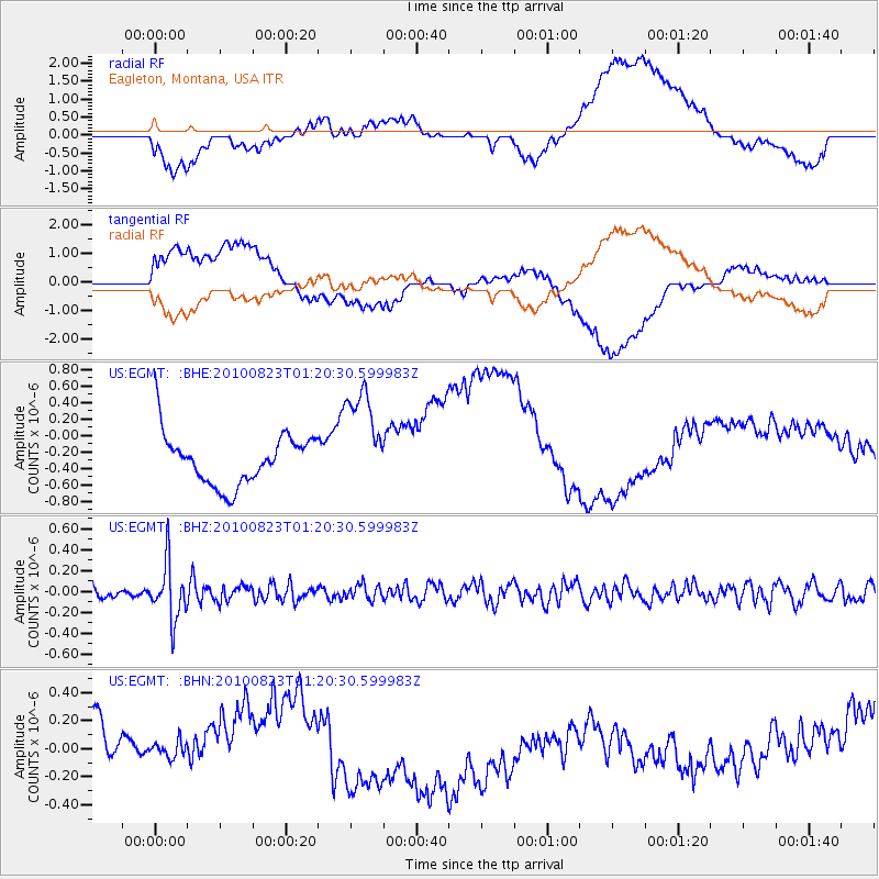
Signal To Noise
| Channel | StoN | STA | LTA |
| US:EGMT: :BHZ:20100823T01:20:30.599983Z | 3.933547 | 2.69636E-7 | 6.85478E-8 |
| US:EGMT: :BHN:20100823T01:20:30.599983Z | 0.29287308 | 8.855344E-8 | 3.0236114E-7 |
| US:EGMT: :BHE:20100823T01:20:30.599983Z | 2.0902684 | 6.402982E-7 | 3.0632347E-7 |
| Arrivals |
| Ps | |
| PpPs | |
| PsPs/PpSs | |


