You are here: Home > Network List > G - GEOSCOPE Stations List
> Station ATD Arta Cave - Arta, Republic of Djibouti > Earthquake Result Viewer
ATD Arta Cave - Arta, Republic of Djibouti - Earthquake Result Viewer
| Earthquake location: |
Talaud Islands, Indonesia |
| Earthquake latitude/longitude: |
4.9/126.3 |
| Earthquake time(UTC): |
2024/01/08 (008) 20:48:46 GMT |
| Earthquake Depth: |
91 km |
| Earthquake Magnitude: |
7.0 Mi |
| Earthquake Catalog/Contributor: |
NEIC PDE/at |
|
| Network: |
G GEOSCOPE |
| Station: |
ATD Arta Cave - Arta, Republic of Djibouti |
| Lat/Lon: |
11.53 N/42.85 E |
| Elevation: |
610 m |
|
| Distance: |
82.7 deg |
| Az: |
280.958 deg |
| Baz: |
86.532 deg |
| Ray Param: |
0.0465414 |
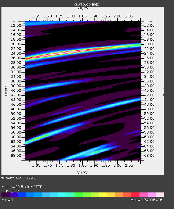
| Estimated Moho Depth: |
23.5 km |
| Estimated Crust Vp/Vs: |
1.77 |
| Assumed Crust Vp: |
6.375 km/s |
| Estimated Crust Vs: |
3.602 km/s |
| Estimated Crust Poisson's Ratio: |
0.27 |
|
| Radial Match: |
96.82961 % |
| Radial Bump: |
400 |
| Transverse Match: |
87.50012 % |
| Transverse Bump: |
400 |
| SOD ConfigId: |
33437571 |
| Insert Time: |
2024-01-22 20:59:03.059 +0000 |
| GWidth: |
2.5 |
| Max Bumps: |
400 |
| Tol: |
0.001 |
|
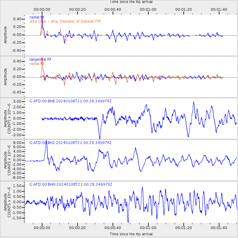
Signal To Noise
| Channel | StoN | STA | LTA |
| G:ATD:00:BHZ:20240108T21:00:28.349976Z | 31.910734 | 3.5580968E-6 | 1.1150156E-7 |
| G:ATD:00:BHN:20240108T21:00:28.349976Z | 2.4501176 | 2.3504269E-7 | 9.593119E-8 |
| G:ATD:00:BHE:20240108T21:00:28.349976Z | 13.035879 | 1.5141229E-6 | 1.1615043E-7 |
| Arrivals |
| Ps | 2.9 SECOND |
| PpPs | 10.0 SECOND |
| PsPs/PpSs | 13 SECOND |


