You are here: Home > Network List > G - GEOSCOPE Stations List
> Station PAF Port aux Francais, Kerguelen (South Indian Ocean) > Earthquake Result Viewer
PAF Port aux Francais, Kerguelen (South Indian Ocean) - Earthquake Result Viewer

| Earthquake location: |
Talaud Islands, Indonesia |
| Earthquake latitude/longitude: |
4.9/126.3 |
| Earthquake time(UTC): |
2024/01/08 (008) 20:48:46 GMT |
| Earthquake Depth: |
91 km |
| Earthquake Magnitude: |
7.0 Mi |
| Earthquake Catalog/Contributor: |
NEIC PDE/at |
|
| Network: |
G GEOSCOPE |
| Station: |
PAF Port aux Francais, Kerguelen (South Indian Ocean) |
| Lat/Lon: |
49.35 S/70.21 E |
| Elevation: |
17 m |
|
| Distance: |
72.6 deg |
| Az: |
214.68 deg |
| Baz: |
60.114 deg |
| Ray Param: |
0.053376682 |
| Estimated Moho Depth: |
43.25 km |
| Estimated Crust Vp/Vs: |
2.03 |
| Assumed Crust Vp: |
4.73 km/s |
| Estimated Crust Vs: |
2.336 km/s |
| Estimated Crust Poisson's Ratio: |
0.34 |
|
| Radial Match: |
82.39868 % |
| Radial Bump: |
400 |
| Transverse Match: |
66.47893 % |
| Transverse Bump: |
400 |
| SOD ConfigId: |
33437571 |
| Insert Time: |
2024-01-22 20:59:12.188 +0000 |
| GWidth: |
2.5 |
| Max Bumps: |
400 |
| Tol: |
0.001 |
|
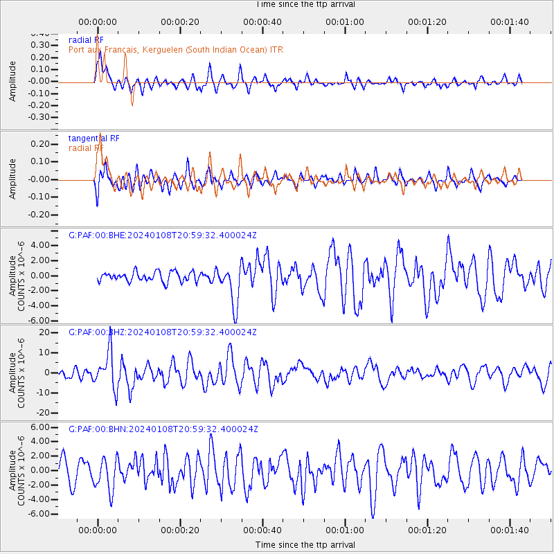
Signal To Noise
| Channel | StoN | STA | LTA |
| G:PAF:00:BHZ:20240108T20:59:32.400024Z | 4.209092 | 9.61761E-6 | 2.2849608E-6 |
| G:PAF:00:BHN:20240108T20:59:32.400024Z | 1.7744882 | 2.2746524E-6 | 1.2818639E-6 |
| G:PAF:00:BHE:20240108T20:59:32.400024Z | 4.2959023 | 2.7351687E-6 | 6.366925E-7 |
| Arrivals |
| Ps | 9.5 SECOND |
| PpPs | 27 SECOND |
| PsPs/PpSs | 37 SECOND |


