You are here: Home > Network List > GO - National Seismic Network of Georgia Stations List
> Station EMLK Emlikli, Georgia > Earthquake Result Viewer
EMLK Emlikli, Georgia - Earthquake Result Viewer
| Earthquake location: |
Talaud Islands, Indonesia |
| Earthquake latitude/longitude: |
4.9/126.3 |
| Earthquake time(UTC): |
2024/01/08 (008) 20:48:46 GMT |
| Earthquake Depth: |
91 km |
| Earthquake Magnitude: |
7.0 Mi |
| Earthquake Catalog/Contributor: |
NEIC PDE/at |
|
| Network: |
GO National Seismic Network of Georgia |
| Station: |
EMLK Emlikli, Georgia |
| Lat/Lon: |
41.21 N/43.95 E |
| Elevation: |
2939 m |
|
| Distance: |
81.1 deg |
| Az: |
310.806 deg |
| Baz: |
91.352 deg |
| Ray Param: |
0.04764441 |
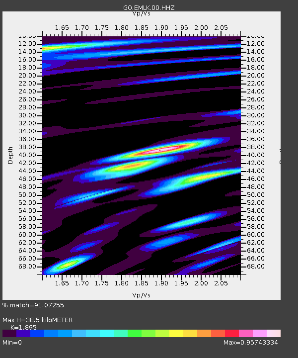
| Estimated Moho Depth: |
38.5 km |
| Estimated Crust Vp/Vs: |
1.89 |
| Assumed Crust Vp: |
6.419 km/s |
| Estimated Crust Vs: |
3.387 km/s |
| Estimated Crust Poisson's Ratio: |
0.31 |
|
| Radial Match: |
91.07255 % |
| Radial Bump: |
400 |
| Transverse Match: |
91.0987 % |
| Transverse Bump: |
391 |
| SOD ConfigId: |
33437571 |
| Insert Time: |
2024-01-22 20:59:35.322 +0000 |
| GWidth: |
2.5 |
| Max Bumps: |
400 |
| Tol: |
0.001 |
|

Signal To Noise
| Channel | StoN | STA | LTA |
| GO:EMLK:00:HHZ:20240108T21:00:20.080017Z | 34.798992 | 3.6168235E-6 | 1.0393472E-7 |
| GO:EMLK:00:HHN:20240108T21:00:20.080017Z | 3.0121143 | 4.3429463E-7 | 1.4418265E-7 |
| GO:EMLK:00:HHE:20240108T21:00:20.080017Z | 9.306809 | 1.3077786E-6 | 1.4051845E-7 |
| Arrivals |
| Ps | 5.5 SECOND |
| PpPs | 17 SECOND |
| PsPs/PpSs | 22 SECOND |


