You are here: Home > Network List > GO - National Seismic Network of Georgia Stations List
> Station KHRT Khreiti, Georgia > Earthquake Result Viewer
KHRT Khreiti, Georgia - Earthquake Result Viewer
| Earthquake location: |
Talaud Islands, Indonesia |
| Earthquake latitude/longitude: |
4.9/126.3 |
| Earthquake time(UTC): |
2024/01/08 (008) 20:48:46 GMT |
| Earthquake Depth: |
91 km |
| Earthquake Magnitude: |
7.0 Mi |
| Earthquake Catalog/Contributor: |
NEIC PDE/at |
|
| Network: |
GO National Seismic Network of Georgia |
| Station: |
KHRT Khreiti, Georgia |
| Lat/Lon: |
42.35 N/43.22 E |
| Elevation: |
1164 m |
|
| Distance: |
81.7 deg |
| Az: |
311.945 deg |
| Baz: |
91.037 deg |
| Ray Param: |
0.047240384 |
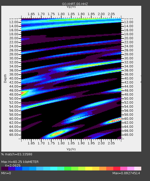
| Estimated Moho Depth: |
60.25 km |
| Estimated Crust Vp/Vs: |
2.08 |
| Assumed Crust Vp: |
6.247 km/s |
| Estimated Crust Vs: |
3.0 km/s |
| Estimated Crust Poisson's Ratio: |
0.35 |
|
| Radial Match: |
83.33598 % |
| Radial Bump: |
400 |
| Transverse Match: |
84.40979 % |
| Transverse Bump: |
400 |
| SOD ConfigId: |
33437571 |
| Insert Time: |
2024-01-22 20:59:38.650 +0000 |
| GWidth: |
2.5 |
| Max Bumps: |
400 |
| Tol: |
0.001 |
|

Signal To Noise
| Channel | StoN | STA | LTA |
| GO:KHRT:00:HHZ:20240108T21:00:23.080017Z | 29.44335 | 2.718846E-6 | 9.23416E-8 |
| GO:KHRT:00:HHN:20240108T21:00:23.080017Z | 2.0203586 | 2.888129E-7 | 1.4295131E-7 |
| GO:KHRT:00:HHE:20240108T21:00:23.080017Z | 9.875464 | 9.4884945E-7 | 9.608149E-8 |
| Arrivals |
| Ps | 11 SECOND |
| PpPs | 29 SECOND |
| PsPs/PpSs | 40 SECOND |


