You are here: Home > Network List > UW - Pacific Northwest Regional Seismic Network Stations List
> Station FISH Seaside, OR, USA > Earthquake Result Viewer
FISH Seaside, OR, USA - Earthquake Result Viewer
*The percent match for this event was below the threshold and hence no stack was calculated.
| Earthquake location: |
South Of Mariana Islands |
| Earthquake latitude/longitude: |
12.8/143.5 |
| Earthquake time(UTC): |
2010/08/23 (235) 01:08:09 GMT |
| Earthquake Depth: |
124 km |
| Earthquake Magnitude: |
5.6 MB, 5.5 MW |
| Earthquake Catalog/Contributor: |
WHDF/NEIC |
|
| Network: |
UW Pacific Northwest Regional Seismic Network |
| Station: |
FISH Seaside, OR, USA |
| Lat/Lon: |
45.93 N/123.56 W |
| Elevation: |
325 m |
|
| Distance: |
82.9 deg |
| Az: |
44.621 deg |
| Baz: |
280.98 deg |
| Ray Param: |
$rayparam |
*The percent match for this event was below the threshold and hence was not used in the summary stack. |
|
| Radial Match: |
50.1879 % |
| Radial Bump: |
400 |
| Transverse Match: |
46.162495 % |
| Transverse Bump: |
400 |
| SOD ConfigId: |
319893 |
| Insert Time: |
2011-01-06 02:12:17.462 +0000 |
| GWidth: |
2.5 |
| Max Bumps: |
400 |
| Tol: |
0.001 |
|
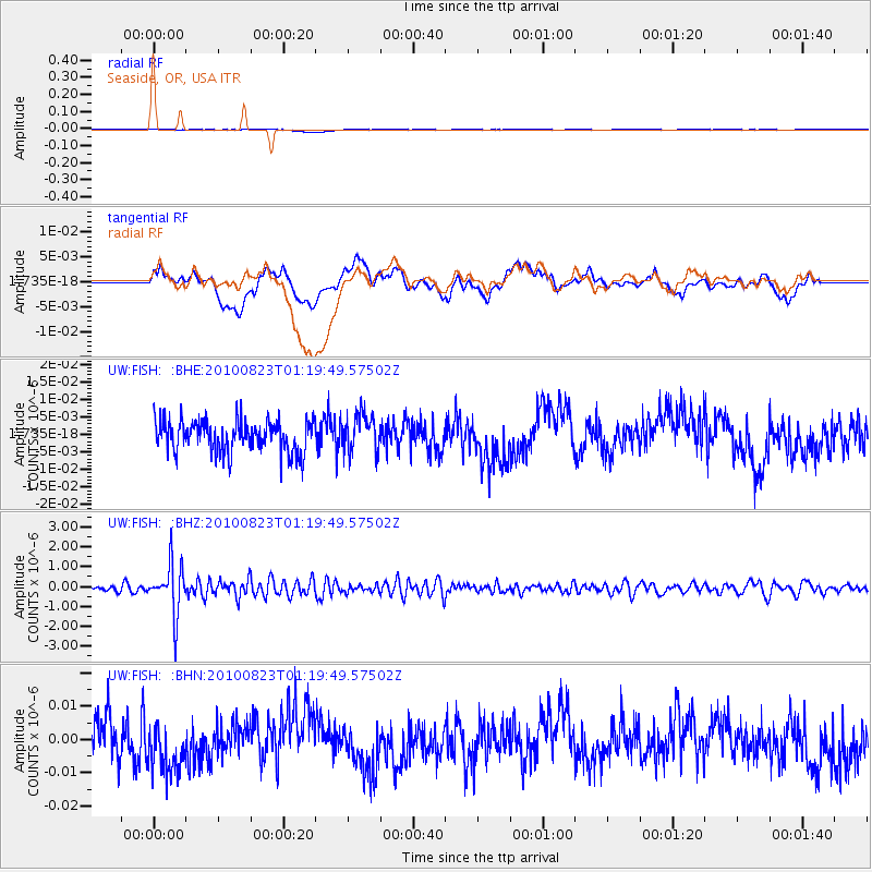
Signal To Noise
| Channel | StoN | STA | LTA |
| UW:FISH: :BHZ:20100823T01:19:49.57502Z | 5.8742476 | 1.2487432E-6 | 2.1257925E-7 |
| UW:FISH: :BHN:20100823T01:19:49.57502Z | 1.4844071 | 8.370559E-9 | 5.638992E-9 |
| UW:FISH: :BHE:20100823T01:19:49.57502Z | 1.226354 | 5.3922093E-9 | 4.3969433E-9 |
| Arrivals |
| Ps | |
| PpPs | |
| PsPs/PpSs | |


