You are here: Home > Network List > IU - Global Seismograph Network (GSN - IRIS/USGS) Stations List
> Station MA2 Magadan, Russia > Earthquake Result Viewer
MA2 Magadan, Russia - Earthquake Result Viewer
| Earthquake location: |
Talaud Islands, Indonesia |
| Earthquake latitude/longitude: |
4.9/126.3 |
| Earthquake time(UTC): |
2024/01/08 (008) 20:48:46 GMT |
| Earthquake Depth: |
91 km |
| Earthquake Magnitude: |
7.0 Mi |
| Earthquake Catalog/Contributor: |
NEIC PDE/at |
|
| Network: |
IU Global Seismograph Network (GSN - IRIS/USGS) |
| Station: |
MA2 Magadan, Russia |
| Lat/Lon: |
59.58 N/150.77 E |
| Elevation: |
339 m |
|
| Distance: |
57.7 deg |
| Az: |
14.426 deg |
| Baz: |
209.194 deg |
| Ray Param: |
0.0630557 |
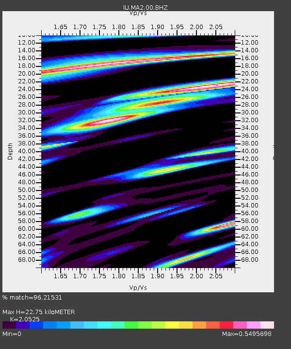
| Estimated Moho Depth: |
22.75 km |
| Estimated Crust Vp/Vs: |
2.05 |
| Assumed Crust Vp: |
6.134 km/s |
| Estimated Crust Vs: |
2.988 km/s |
| Estimated Crust Poisson's Ratio: |
0.34 |
|
| Radial Match: |
96.21531 % |
| Radial Bump: |
362 |
| Transverse Match: |
89.52085 % |
| Transverse Bump: |
400 |
| SOD ConfigId: |
33437571 |
| Insert Time: |
2024-01-22 21:01:18.585 +0000 |
| GWidth: |
2.5 |
| Max Bumps: |
400 |
| Tol: |
0.001 |
|
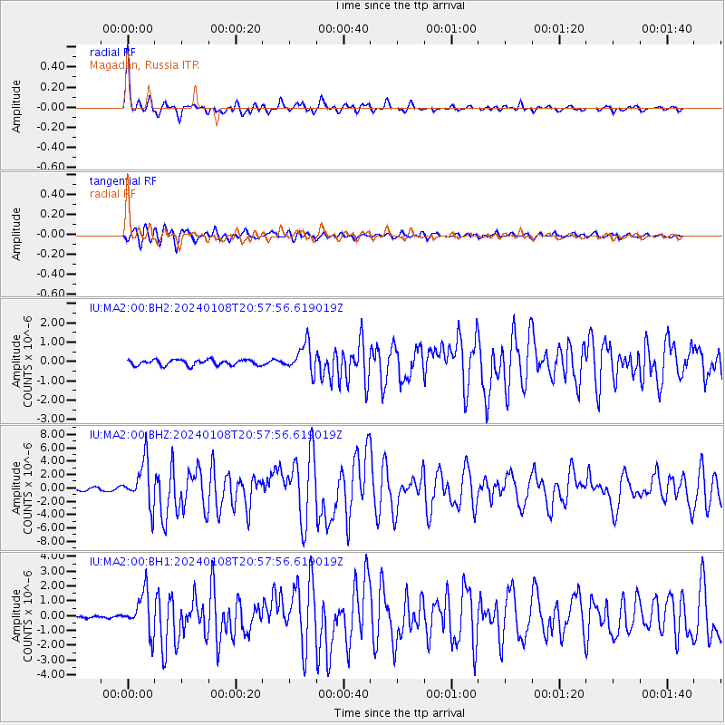
Signal To Noise
| Channel | StoN | STA | LTA |
| IU:MA2:00:BHZ:20240108T20:57:56.619019Z | 20.890541 | 3.3213585E-6 | 1.5898863E-7 |
| IU:MA2:00:BH1:20240108T20:57:56.619019Z | 14.233911 | 1.3625964E-6 | 9.5728886E-8 |
| IU:MA2:00:BH2:20240108T20:57:56.619019Z | 5.0626974 | 7.345269E-7 | 1.4508608E-7 |
| Arrivals |
| Ps | 4.1 SECOND |
| PpPs | 11 SECOND |
| PsPs/PpSs | 15 SECOND |


