You are here: Home > Network List > UW - Pacific Northwest Regional Seismic Network Stations List
> Station LEBA Lebam, WA, USA > Earthquake Result Viewer
LEBA Lebam, WA, USA - Earthquake Result Viewer
*The percent match for this event was below the threshold and hence no stack was calculated.
| Earthquake location: |
South Of Mariana Islands |
| Earthquake latitude/longitude: |
12.8/143.5 |
| Earthquake time(UTC): |
2010/08/23 (235) 01:08:09 GMT |
| Earthquake Depth: |
124 km |
| Earthquake Magnitude: |
5.6 MB, 5.5 MW |
| Earthquake Catalog/Contributor: |
WHDF/NEIC |
|
| Network: |
UW Pacific Northwest Regional Seismic Network |
| Station: |
LEBA Lebam, WA, USA |
| Lat/Lon: |
46.55 N/123.56 W |
| Elevation: |
73 m |
|
| Distance: |
82.8 deg |
| Az: |
44.012 deg |
| Baz: |
280.901 deg |
| Ray Param: |
$rayparam |
*The percent match for this event was below the threshold and hence was not used in the summary stack. |
|
| Radial Match: |
65.789154 % |
| Radial Bump: |
400 |
| Transverse Match: |
68.19424 % |
| Transverse Bump: |
400 |
| SOD ConfigId: |
319893 |
| Insert Time: |
2011-01-06 02:12:34.052 +0000 |
| GWidth: |
2.5 |
| Max Bumps: |
400 |
| Tol: |
0.001 |
|
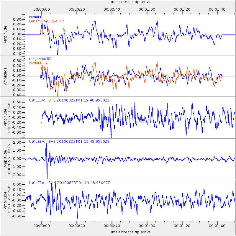
Signal To Noise
| Channel | StoN | STA | LTA |
| UW:LEBA: :BHZ:20100823T01:19:48.95002Z | 6.969611 | 8.343041E-7 | 1.1970597E-7 |
| UW:LEBA: :BHN:20100823T01:19:48.95002Z | 1.4205922 | 1.9883142E-7 | 1.3996376E-7 |
| UW:LEBA: :BHE:20100823T01:19:48.95002Z | 1.838166 | 2.1877017E-7 | 1.1901546E-7 |
| Arrivals |
| Ps | |
| PpPs | |
| PsPs/PpSs | |


