You are here: Home > Network List > MM - Myanmar National Seismic Network Stations List
> Station KTN Keng Tun, Shan, Myanmar > Earthquake Result Viewer
KTN Keng Tun, Shan, Myanmar - Earthquake Result Viewer
| Earthquake location: |
Talaud Islands, Indonesia |
| Earthquake latitude/longitude: |
4.9/126.3 |
| Earthquake time(UTC): |
2024/01/08 (008) 20:48:46 GMT |
| Earthquake Depth: |
91 km |
| Earthquake Magnitude: |
7.0 Mi |
| Earthquake Catalog/Contributor: |
NEIC PDE/at |
|
| Network: |
MM Myanmar National Seismic Network |
| Station: |
KTN Keng Tun, Shan, Myanmar |
| Lat/Lon: |
21.29 N/99.59 E |
| Elevation: |
832 m |
|
| Distance: |
30.6 deg |
| Az: |
304.61 deg |
| Baz: |
118.432 deg |
| Ray Param: |
0.07916407 |
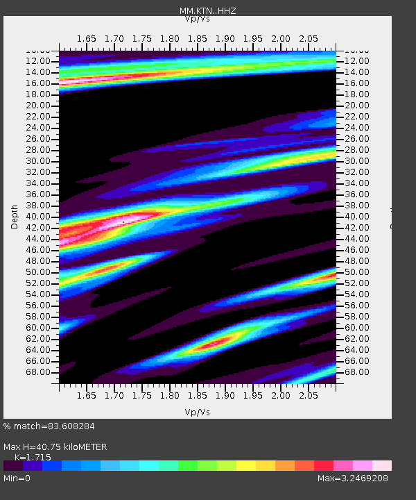
| Estimated Moho Depth: |
40.75 km |
| Estimated Crust Vp/Vs: |
1.72 |
| Assumed Crust Vp: |
6.316 km/s |
| Estimated Crust Vs: |
3.683 km/s |
| Estimated Crust Poisson's Ratio: |
0.24 |
|
| Radial Match: |
83.608284 % |
| Radial Bump: |
396 |
| Transverse Match: |
77.69494 % |
| Transverse Bump: |
378 |
| SOD ConfigId: |
33437571 |
| Insert Time: |
2024-01-22 21:02:37.138 +0000 |
| GWidth: |
2.5 |
| Max Bumps: |
400 |
| Tol: |
0.001 |
|

Signal To Noise
| Channel | StoN | STA | LTA |
| MM:KTN: :HHZ:20240108T20:54:21.537994Z | 34.782726 | 4.526073E-6 | 1.3012418E-7 |
| MM:KTN: :HHN:20240108T20:54:21.537994Z | 8.193184 | 2.0579166E-6 | 2.5117424E-7 |
| MM:KTN: :HHE:20240108T20:54:21.537994Z | 9.493617 | 2.7445783E-6 | 2.890972E-7 |
| Arrivals |
| Ps | 5.0 SECOND |
| PpPs | 16 SECOND |
| PsPs/PpSs | 21 SECOND |


