You are here: Home > Network List > S1 - Australian Seismometers in Schools Stations List
> Station AUMBR Murray Bridge High School > Earthquake Result Viewer
AUMBR Murray Bridge High School - Earthquake Result Viewer
| Earthquake location: |
Talaud Islands, Indonesia |
| Earthquake latitude/longitude: |
4.9/126.3 |
| Earthquake time(UTC): |
2024/01/08 (008) 20:48:46 GMT |
| Earthquake Depth: |
91 km |
| Earthquake Magnitude: |
7.0 Mi |
| Earthquake Catalog/Contributor: |
NEIC PDE/at |
|
| Network: |
S1 Australian Seismometers in Schools |
| Station: |
AUMBR Murray Bridge High School |
| Lat/Lon: |
35.13 S/139.29 E |
| Elevation: |
50 m |
|
| Distance: |
41.6 deg |
| Az: |
163.928 deg |
| Baz: |
340.331 deg |
| Ray Param: |
0.07336833 |
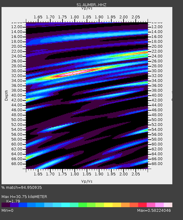
| Estimated Moho Depth: |
30.75 km |
| Estimated Crust Vp/Vs: |
1.79 |
| Assumed Crust Vp: |
6.576 km/s |
| Estimated Crust Vs: |
3.674 km/s |
| Estimated Crust Poisson's Ratio: |
0.27 |
|
| Radial Match: |
94.950935 % |
| Radial Bump: |
319 |
| Transverse Match: |
76.59615 % |
| Transverse Bump: |
400 |
| SOD ConfigId: |
33437571 |
| Insert Time: |
2024-01-22 21:04:03.942 +0000 |
| GWidth: |
2.5 |
| Max Bumps: |
400 |
| Tol: |
0.001 |
|

Signal To Noise
| Channel | StoN | STA | LTA |
| S1:AUMBR: :HHZ:20240108T20:55:54.649994Z | 4.969151 | 2.2631243E-6 | 4.554348E-7 |
| S1:AUMBR: :HHN:20240108T20:55:54.649994Z | 3.5797966 | 1.3128929E-6 | 3.667507E-7 |
| S1:AUMBR: :HHE:20240108T20:55:54.649994Z | 0.54395455 | 3.320457E-7 | 6.104291E-7 |
| Arrivals |
| Ps | 4.0 SECOND |
| PpPs | 12 SECOND |
| PsPs/PpSs | 16 SECOND |


