You are here: Home > Network List > XG92 - Rocky Mountain Front Stations List
> Station BUR Burlington, CO > Earthquake Result Viewer
BUR Burlington, CO - Earthquake Result Viewer
| Earthquake location: |
Near Coast Of Nicaragua |
| Earthquake latitude/longitude: |
11.8/-87.4 |
| Earthquake time(UTC): |
1992/09/02 (246) 00:15:57 GMT |
| Earthquake Depth: |
10 km |
| Earthquake Magnitude: |
5.3 MB, 7.2 MS |
| Earthquake Catalog/Contributor: |
WHDF/NEIC |
|
| Network: |
XG Rocky Mountain Front |
| Station: |
BUR Burlington, CO |
| Lat/Lon: |
39.39 N/102.35 W |
| Elevation: |
1255 m |
|
| Distance: |
30.5 deg |
| Az: |
336.862 deg |
| Baz: |
150.228 deg |
| Ray Param: |
0.079304785 |
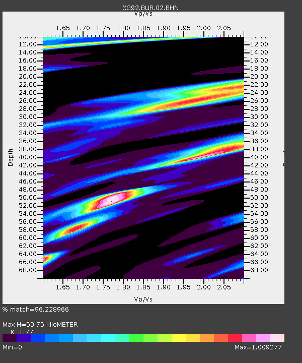
| Estimated Moho Depth: |
50.75 km |
| Estimated Crust Vp/Vs: |
1.77 |
| Assumed Crust Vp: |
6.242 km/s |
| Estimated Crust Vs: |
3.527 km/s |
| Estimated Crust Poisson's Ratio: |
0.27 |
|
| Radial Match: |
96.228966 % |
| Radial Bump: |
242 |
| Transverse Match: |
81.94053 % |
| Transverse Bump: |
400 |
| SOD ConfigId: |
3286 |
| Insert Time: |
2010-02-25 20:07:57.372 +0000 |
| GWidth: |
2.5 |
| Max Bumps: |
400 |
| Tol: |
0.001 |
|
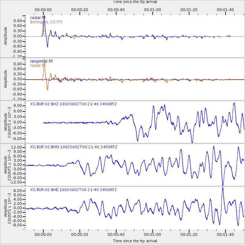
Signal To Noise
| Channel | StoN | STA | LTA |
| XG:BUR:02:BHN:19920902T00:21:40.346985Z | 1.3289804 | 2.1024836E-4 | 1.5820275E-4 |
| XG:BUR:02:BHE:19920902T00:21:40.346985Z | 1.5773859 | 2.4302809E-4 | 1.5407016E-4 |
| XG:BUR:02:BHZ:19920902T00:21:40.346985Z | 2.352947 | 2.9451624E-4 | 1.251691E-4 |
| Arrivals |
| Ps | 6.8 SECOND |
| PpPs | 21 SECOND |
| PsPs/PpSs | 28 SECOND |


