You are here: Home > Network List > IW - Intermountain West Stations List
> Station MOOW Moose Ponds, Wyoming, USA > Earthquake Result Viewer
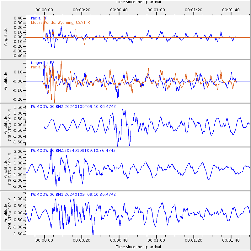
MOOW Moose Ponds, Wyoming, USA - Earthquake Result Viewer
*The percent match for this event was below the threshold and hence no stack was calculated.
| Earthquake location: |
Near West Coast Of Honshu, Japan |
| Earthquake latitude/longitude: |
37.9/137.7 |
| Earthquake time(UTC): |
2024/01/09 (009) 08:59:10 GMT |
| Earthquake Depth: |
11 km |
| Earthquake Magnitude: |
5.8 Mww |
| Earthquake Catalog/Contributor: |
NEIC PDE/us |
|
| Network: |
IW Intermountain West |
| Station: |
MOOW Moose Ponds, Wyoming, USA |
| Lat/Lon: |
43.75 N/110.74 W |
| Elevation: |
2128 m |
|
| Distance: |
77.8 deg |
| Az: |
43.592 deg |
| Baz: |
311.151 deg |
| Ray Param: |
$rayparam |
*The percent match for this event was below the threshold and hence was not used in the summary stack. |
|
| Radial Match: |
72.3113 % |
| Radial Bump: |
400 |
| Transverse Match: |
78.84394 % |
| Transverse Bump: |
400 |
| SOD ConfigId: |
33437571 |
| Insert Time: |
2024-01-23 09:20:29.952 +0000 |
| GWidth: |
2.5 |
| Max Bumps: |
400 |
| Tol: |
0.001 |
|
Signal To Noise
| Channel | StoN | STA | LTA |
| IW:MOOW:00:BHZ:20240109T09:10:36.474Z | 3.0176234 | 1.5425026E-6 | 5.111647E-7 |
| IW:MOOW:00:BH1:20240109T09:10:36.474Z | 1.078256 | 4.1982472E-7 | 3.8935534E-7 |
| IW:MOOW:00:BH2:20240109T09:10:36.474Z | 1.303546 | 4.1683126E-7 | 3.197672E-7 |
| Arrivals |
| Ps | |
| PpPs | |
| PsPs/PpSs | |


