You are here: Home > Network List > IU - Global Seismograph Network (GSN - IRIS/USGS) Stations List
> Station XMAS Kiritimati Island, Republic of Kiribati > Earthquake Result Viewer
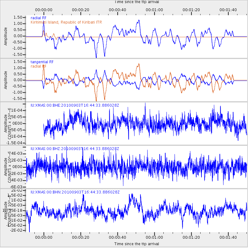
XMAS Kiritimati Island, Republic of Kiribati - Earthquake Result Viewer
*The percent match for this event was below the threshold and hence no stack was calculated.
| Earthquake location: |
South Island, New Zealand |
| Earthquake latitude/longitude: |
-43.5/171.8 |
| Earthquake time(UTC): |
2010/09/03 (246) 16:35:47 GMT |
| Earthquake Depth: |
12 km |
| Earthquake Magnitude: |
6.4 MB, 7.3 MS, 7.0 MW, 7.0 MW |
| Earthquake Catalog/Contributor: |
WHDF/NEIC |
|
| Network: |
IU Global Seismograph Network (GSN - IRIS/USGS) |
| Station: |
XMAS Kiritimati Island, Republic of Kiribati |
| Lat/Lon: |
2.04 N/157.45 W |
| Elevation: |
20 m |
|
| Distance: |
53.1 deg |
| Az: |
39.687 deg |
| Baz: |
207.698 deg |
| Ray Param: |
$rayparam |
*The percent match for this event was below the threshold and hence was not used in the summary stack. |
|
| Radial Match: |
65.7407 % |
| Radial Bump: |
400 |
| Transverse Match: |
65.66076 % |
| Transverse Bump: |
400 |
| SOD ConfigId: |
319893 |
| Insert Time: |
2011-01-13 07:39:48.256 +0000 |
| GWidth: |
2.5 |
| Max Bumps: |
400 |
| Tol: |
0.001 |
|
Signal To Noise
| Channel | StoN | STA | LTA |
| IU:XMAS:00:BHZ:20100903T16:44:33.886028Z | 0.94663423 | 1.4958071E-9 | 1.5801321E-9 |
| IU:XMAS:00:BHN:20100903T16:44:33.886028Z | 0.75069 | 3.718293E-9 | 4.953167E-9 |
| IU:XMAS:00:BHE:20100903T16:44:33.886028Z | 0.7603263 | 3.48326E-11 | 4.5812697E-11 |
| Arrivals |
| Ps | |
| PpPs | |
| PsPs/PpSs | |


