You are here: Home > Network List > UW - Pacific Northwest Regional Seismic Network Stations List
> Station HOOD Mt Hood Meadows, OR CREST BB SMO > Earthquake Result Viewer
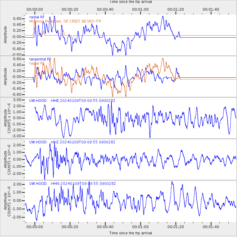
HOOD Mt Hood Meadows, OR CREST BB SMO - Earthquake Result Viewer
*The percent match for this event was below the threshold and hence no stack was calculated.
| Earthquake location: |
Near West Coast Of Honshu, Japan |
| Earthquake latitude/longitude: |
37.9/137.7 |
| Earthquake time(UTC): |
2024/01/09 (009) 08:59:10 GMT |
| Earthquake Depth: |
11 km |
| Earthquake Magnitude: |
5.8 Mww |
| Earthquake Catalog/Contributor: |
NEIC PDE/us |
|
| Network: |
UW Pacific Northwest Regional Seismic Network |
| Station: |
HOOD Mt Hood Meadows, OR CREST BB SMO |
| Lat/Lon: |
45.32 N/121.65 W |
| Elevation: |
1520 m |
|
| Distance: |
70.7 deg |
| Az: |
47.272 deg |
| Baz: |
304.513 deg |
| Ray Param: |
$rayparam |
*The percent match for this event was below the threshold and hence was not used in the summary stack. |
|
| Radial Match: |
54.10535 % |
| Radial Bump: |
400 |
| Transverse Match: |
48.725647 % |
| Transverse Bump: |
400 |
| SOD ConfigId: |
33437571 |
| Insert Time: |
2024-01-23 09:34:28.208 +0000 |
| GWidth: |
2.5 |
| Max Bumps: |
400 |
| Tol: |
0.001 |
|
Signal To Noise
| Channel | StoN | STA | LTA |
| UW:HOOD: :HHZ:20240109T09:09:55.090028Z | 1.4761475 | 7.553509E-7 | 5.1170423E-7 |
| UW:HOOD: :HHN:20240109T09:09:55.090028Z | 1.5318408 | 1.3413489E-6 | 8.756451E-7 |
| UW:HOOD: :HHE:20240109T09:09:55.090028Z | 0.9921041 | 1.3260222E-6 | 1.3365757E-6 |
| Arrivals |
| Ps | |
| PpPs | |
| PsPs/PpSs | |


