You are here: Home > Network List > XG92 - Rocky Mountain Front Stations List
> Station BUR Burlington, CO > Earthquake Result Viewer
BUR Burlington, CO - Earthquake Result Viewer
| Earthquake location: |
Hokkaido, Japan Region |
| Earthquake latitude/longitude: |
41.9/140.7 |
| Earthquake time(UTC): |
1992/08/24 (237) 06:59:40 GMT |
| Earthquake Depth: |
127 km |
| Earthquake Magnitude: |
6.2 MB |
| Earthquake Catalog/Contributor: |
WHDF/NEIC |
|
| Network: |
XG Rocky Mountain Front |
| Station: |
BUR Burlington, CO |
| Lat/Lon: |
39.39 N/102.35 W |
| Elevation: |
1255 m |
|
| Distance: |
80.8 deg |
| Az: |
44.414 deg |
| Baz: |
317.642 deg |
| Ray Param: |
0.047702014 |
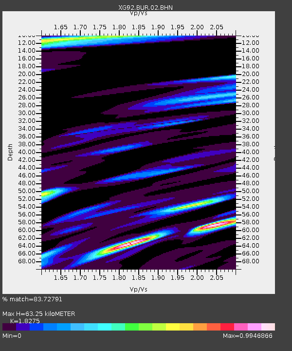
| Estimated Moho Depth: |
63.25 km |
| Estimated Crust Vp/Vs: |
1.83 |
| Assumed Crust Vp: |
6.242 km/s |
| Estimated Crust Vs: |
3.416 km/s |
| Estimated Crust Poisson's Ratio: |
0.29 |
|
| Radial Match: |
83.72791 % |
| Radial Bump: |
400 |
| Transverse Match: |
75.730675 % |
| Transverse Bump: |
400 |
| SOD ConfigId: |
3286 |
| Insert Time: |
2010-02-25 20:07:58.762 +0000 |
| GWidth: |
2.5 |
| Max Bumps: |
400 |
| Tol: |
0.001 |
|
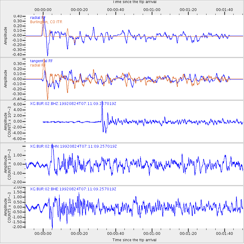
Signal To Noise
| Channel | StoN | STA | LTA |
| XG:BUR:02:BHN:19920824T07:11:09.257019Z | 2.9714544 | 5.283803E-4 | 1.7781874E-4 |
| XG:BUR:02:BHE:19920824T07:11:09.257019Z | 2.4686394 | 4.906261E-4 | 1.9874352E-4 |
| XG:BUR:02:BHZ:19920824T07:11:09.257019Z | 20.357407 | 0.0022872535 | 1.12354865E-4 |
| Arrivals |
| Ps | 8.6 SECOND |
| PpPs | 28 SECOND |
| PsPs/PpSs | 37 SECOND |


