You are here: Home > Network List > AK - Alaska Regional Network Stations List
> Station MDM Murphy Dome > Earthquake Result Viewer
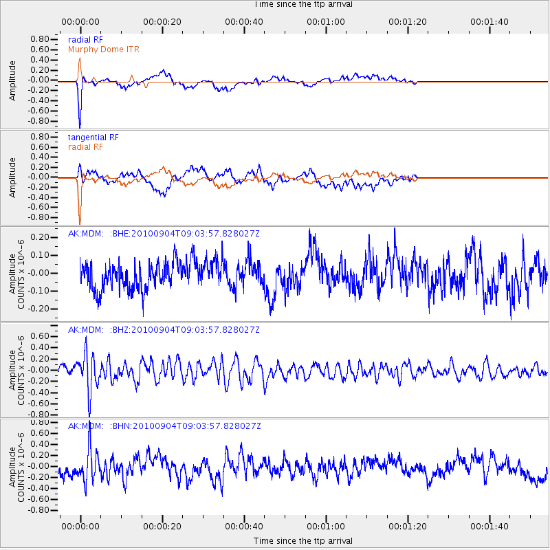
MDM Murphy Dome - Earthquake Result Viewer
*The percent match for this event was below the threshold and hence no stack was calculated.
| Earthquake location: |
Tonga Islands |
| Earthquake latitude/longitude: |
-17.4/-174.0 |
| Earthquake time(UTC): |
2010/09/04 (247) 08:52:04 GMT |
| Earthquake Depth: |
69 km |
| Earthquake Magnitude: |
5.9 MB, 6.1 MW, 6.0 MW |
| Earthquake Catalog/Contributor: |
WHDF/NEIC |
|
| Network: |
AK Alaska Regional Network |
| Station: |
MDM Murphy Dome |
| Lat/Lon: |
64.96 N/148.23 W |
| Elevation: |
634 m |
|
| Distance: |
84.4 deg |
| Az: |
10.715 deg |
| Baz: |
204.656 deg |
| Ray Param: |
$rayparam |
*The percent match for this event was below the threshold and hence was not used in the summary stack. |
|
| Radial Match: |
73.1649 % |
| Radial Bump: |
331 |
| Transverse Match: |
55.573257 % |
| Transverse Bump: |
400 |
| SOD ConfigId: |
319893 |
| Insert Time: |
2011-01-13 07:48:38.500 +0000 |
| GWidth: |
2.5 |
| Max Bumps: |
400 |
| Tol: |
0.001 |
|
Signal To Noise
| Channel | StoN | STA | LTA |
| AK:MDM: :BHZ:20100904T09:03:57.828027Z | 3.8404582 | 3.3305705E-7 | 8.672326E-8 |
| AK:MDM: :BHN:20100904T09:03:57.828027Z | 2.7674263 | 2.9808265E-7 | 1.07711145E-7 |
| AK:MDM: :BHE:20100904T09:03:57.828027Z | 1.1344205 | 8.1039744E-8 | 7.143713E-8 |
| Arrivals |
| Ps | |
| PpPs | |
| PsPs/PpSs | |


