You are here: Home > Network List > AZ - ANZA Regional Network Stations List
> Station CPE Camp Elliot, Miramar, CA, USA > Earthquake Result Viewer
CPE Camp Elliot, Miramar, CA, USA - Earthquake Result Viewer
| Earthquake location: |
Kermadec Islands, New Zealand |
| Earthquake latitude/longitude: |
-29.8/-177.7 |
| Earthquake time(UTC): |
2008/09/29 (273) 15:19:31 GMT |
| Earthquake Depth: |
36 km |
| Earthquake Magnitude: |
6.5 MB, 6.7 MS, 7.0 MW, 7.0 MW |
| Earthquake Catalog/Contributor: |
WHDF/NEIC |
|
| Network: |
AZ ANZA Regional Network |
| Station: |
CPE Camp Elliot, Miramar, CA, USA |
| Lat/Lon: |
32.89 N/117.11 W |
| Elevation: |
150 m |
|
| Distance: |
84.7 deg |
| Az: |
47.394 deg |
| Baz: |
229.525 deg |
| Ray Param: |
0.045251705 |
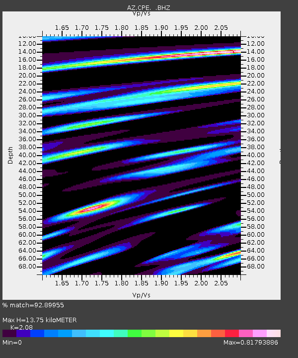
| Estimated Moho Depth: |
13.75 km |
| Estimated Crust Vp/Vs: |
2.08 |
| Assumed Crust Vp: |
6.264 km/s |
| Estimated Crust Vs: |
3.011 km/s |
| Estimated Crust Poisson's Ratio: |
0.35 |
|
| Radial Match: |
92.89955 % |
| Radial Bump: |
400 |
| Transverse Match: |
85.98232 % |
| Transverse Bump: |
400 |
| SOD ConfigId: |
2560 |
| Insert Time: |
2010-02-26 18:53:29.838 +0000 |
| GWidth: |
2.5 |
| Max Bumps: |
400 |
| Tol: |
0.001 |
|

Signal To Noise
| Channel | StoN | STA | LTA |
| AZ:CPE: :BHZ:20080929T15:31:30.545017Z | 3.9329522 | 7.8600397E-7 | 1.9985087E-7 |
| AZ:CPE: :BHN:20080929T15:31:30.545017Z | 1.3727658 | 2.2481264E-7 | 1.637662E-7 |
| AZ:CPE: :BHE:20080929T15:31:30.545017Z | 1.7622613 | 2.3054878E-7 | 1.3082554E-7 |
| Arrivals |
| Ps | 2.4 SECOND |
| PpPs | 6.6 SECOND |
| PsPs/PpSs | 9.0 SECOND |


