You are here: Home > Network List > XG92 - Rocky Mountain Front Stations List
> Station BUR Burlington, CO > Earthquake Result Viewer
BUR Burlington, CO - Earthquake Result Viewer
| Earthquake location: |
South Of Panama |
| Earthquake latitude/longitude: |
6.1/-82.4 |
| Earthquake time(UTC): |
1992/06/26 (178) 11:32:30 GMT |
| Earthquake Depth: |
33 km |
| Earthquake Magnitude: |
5.8 MB, 5.4 MS |
| Earthquake Catalog/Contributor: |
WHDF/NEIC |
|
| Network: |
XG Rocky Mountain Front |
| Station: |
BUR Burlington, CO |
| Lat/Lon: |
39.39 N/102.35 W |
| Elevation: |
1255 m |
|
| Distance: |
37.7 deg |
| Az: |
334.339 deg |
| Baz: |
146.244 deg |
| Ray Param: |
0.07592359 |
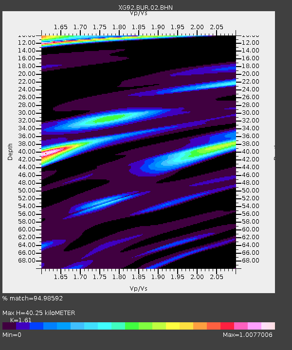
| Estimated Moho Depth: |
40.25 km |
| Estimated Crust Vp/Vs: |
1.61 |
| Assumed Crust Vp: |
6.242 km/s |
| Estimated Crust Vs: |
3.877 km/s |
| Estimated Crust Poisson's Ratio: |
0.19 |
|
| Radial Match: |
94.98592 % |
| Radial Bump: |
198 |
| Transverse Match: |
79.79566 % |
| Transverse Bump: |
400 |
| SOD ConfigId: |
3286 |
| Insert Time: |
2010-02-25 20:08:02.843 +0000 |
| GWidth: |
2.5 |
| Max Bumps: |
400 |
| Tol: |
0.001 |
|
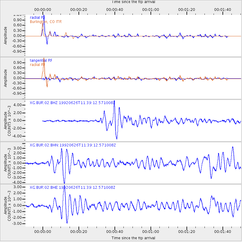
Signal To Noise
| Channel | StoN | STA | LTA |
| XG:BUR:02:BHN:19920626T11:39:12.571008Z | 3.0427651 | 3.491644E-4 | 1.1475233E-4 |
| XG:BUR:02:BHE:19920626T11:39:12.571008Z | 1.8192264 | 2.3886506E-4 | 1.3130034E-4 |
| XG:BUR:02:BHZ:19920626T11:39:12.571008Z | 10.653006 | 8.632703E-4 | 8.1035374E-5 |
| Arrivals |
| Ps | 4.2 SECOND |
| PpPs | 16 SECOND |
| PsPs/PpSs | 20 SECOND |


