You are here: Home > Network List > US - United States National Seismic Network Stations List
> Station MNTX Cornudas Mountains, Texas, USA > Earthquake Result Viewer
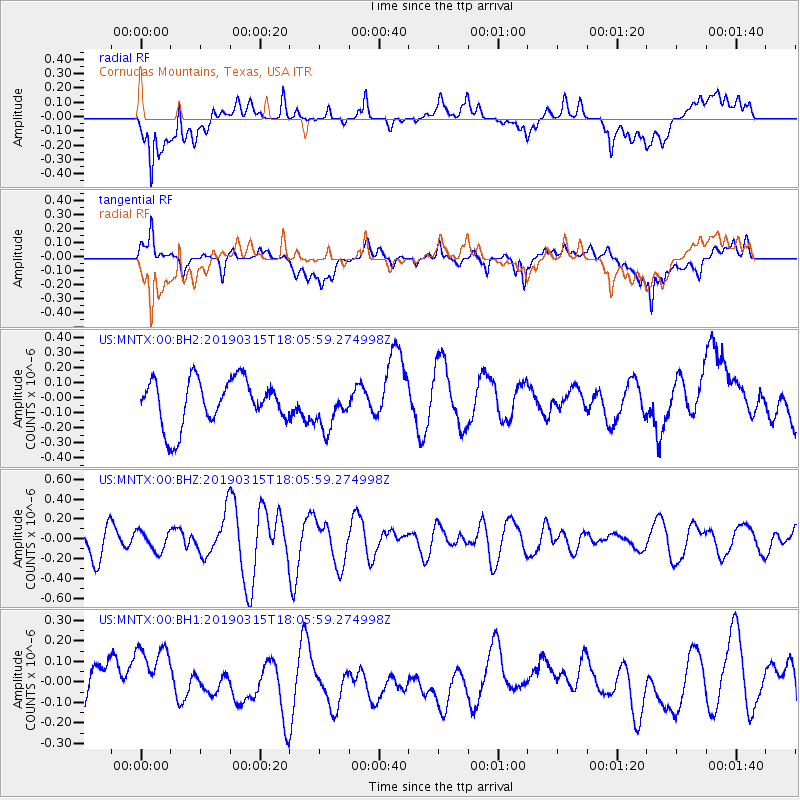
MNTX Cornudas Mountains, Texas, USA - Earthquake Result Viewer
*The percent match for this event was below the threshold and hence no stack was calculated.
| Earthquake location: |
Kermadec Islands Region |
| Earthquake latitude/longitude: |
-27.6/-176.3 |
| Earthquake time(UTC): |
2019/03/15 (074) 17:53:33 GMT |
| Earthquake Depth: |
10 km |
| Earthquake Magnitude: |
5.5 Mww |
| Earthquake Catalog/Contributor: |
NEIC PDE/us |
|
| Network: |
US United States National Seismic Network |
| Station: |
MNTX Cornudas Mountains, Texas, USA |
| Lat/Lon: |
31.70 N/105.38 W |
| Elevation: |
404 m |
|
| Distance: |
89.6 deg |
| Az: |
53.644 deg |
| Baz: |
236.983 deg |
| Ray Param: |
$rayparam |
*The percent match for this event was below the threshold and hence was not used in the summary stack. |
|
| Radial Match: |
51.65211 % |
| Radial Bump: |
400 |
| Transverse Match: |
51.70234 % |
| Transverse Bump: |
400 |
| SOD ConfigId: |
3338192 |
| Insert Time: |
2019-03-29 18:10:42.713 +0000 |
| GWidth: |
2.5 |
| Max Bumps: |
400 |
| Tol: |
0.001 |
|
Signal To Noise
| Channel | StoN | STA | LTA |
| US:MNTX:00:BHZ:20190315T18:05:59.274998Z | 0.70958686 | 1.0049174E-7 | 1.4162006E-7 |
| US:MNTX:00:BH1:20190315T18:05:59.274998Z | 1.5084058 | 2.060411E-7 | 1.3659528E-7 |
| US:MNTX:00:BH2:20190315T18:05:59.274998Z | 0.9288079 | 1.4160143E-7 | 1.5245503E-7 |
| Arrivals |
| Ps | |
| PpPs | |
| PsPs/PpSs | |


