You are here: Home > Network List > US - United States National Seismic Network Stations List
> Station MNTX Cornudas Mountains, Texas, USA > Earthquake Result Viewer
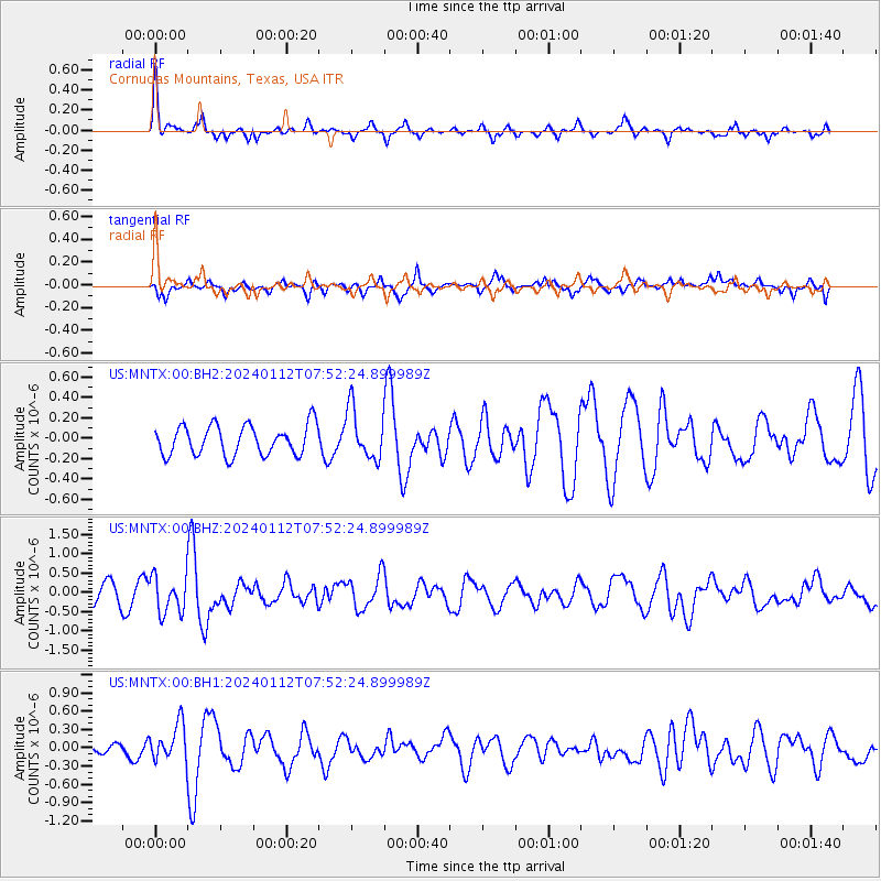
MNTX Cornudas Mountains, Texas, USA - Earthquake Result Viewer
*The percent match for this event was below the threshold and hence no stack was calculated.
| Earthquake location: |
Off Coast Of Southeastern Alaska |
| Earthquake latitude/longitude: |
56.5/-136.0 |
| Earthquake time(UTC): |
2024/01/12 (012) 07:46:21 GMT |
| Earthquake Depth: |
0.6 km |
| Earthquake Magnitude: |
5.9 mww |
| Earthquake Catalog/Contributor: |
NEIC PDE/ak |
|
| Network: |
US United States National Seismic Network |
| Station: |
MNTX Cornudas Mountains, Texas, USA |
| Lat/Lon: |
31.70 N/105.38 W |
| Elevation: |
405 m |
|
| Distance: |
32.7 deg |
| Az: |
126.428 deg |
| Baz: |
328.448 deg |
| Ray Param: |
$rayparam |
*The percent match for this event was below the threshold and hence was not used in the summary stack. |
|
| Radial Match: |
64.46633 % |
| Radial Bump: |
288 |
| Transverse Match: |
60.45901 % |
| Transverse Bump: |
380 |
| SOD ConfigId: |
33437571 |
| Insert Time: |
2024-01-26 08:19:39.862 +0000 |
| GWidth: |
2.5 |
| Max Bumps: |
400 |
| Tol: |
0.001 |
|
Signal To Noise
| Channel | StoN | STA | LTA |
| US:MNTX:00:BHZ:20240112T07:52:24.899989Z | 1.9923284 | 4.764051E-7 | 2.3911974E-7 |
| US:MNTX:00:BH1:20240112T07:52:24.899989Z | 3.8606403 | 3.0935684E-7 | 8.013097E-8 |
| US:MNTX:00:BH2:20240112T07:52:24.899989Z | 1.700543 | 2.478687E-7 | 1.4575856E-7 |
| Arrivals |
| Ps | |
| PpPs | |
| PsPs/PpSs | |


