You are here: Home > Network List > CI - Caltech Regional Seismic Network Stations List
> Station RRX Rimrock Road, Barstow, CA, USA > Earthquake Result Viewer
RRX Rimrock Road, Barstow, CA, USA - Earthquake Result Viewer
| Earthquake location: |
Tonga Islands |
| Earthquake latitude/longitude: |
-17.4/-174.0 |
| Earthquake time(UTC): |
2010/09/04 (247) 08:52:04 GMT |
| Earthquake Depth: |
69 km |
| Earthquake Magnitude: |
5.9 MB, 6.1 MW, 6.0 MW |
| Earthquake Catalog/Contributor: |
WHDF/NEIC |
|
| Network: |
CI Caltech Regional Seismic Network |
| Station: |
RRX Rimrock Road, Barstow, CA, USA |
| Lat/Lon: |
34.88 N/117.00 W |
| Elevation: |
439 m |
|
| Distance: |
75.0 deg |
| Az: |
45.551 deg |
| Baz: |
236.013 deg |
| Ray Param: |
0.05181159 |
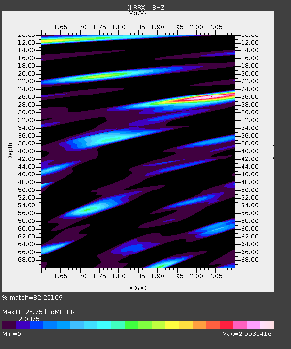
| Estimated Moho Depth: |
25.75 km |
| Estimated Crust Vp/Vs: |
2.04 |
| Assumed Crust Vp: |
6.276 km/s |
| Estimated Crust Vs: |
3.08 km/s |
| Estimated Crust Poisson's Ratio: |
0.34 |
|
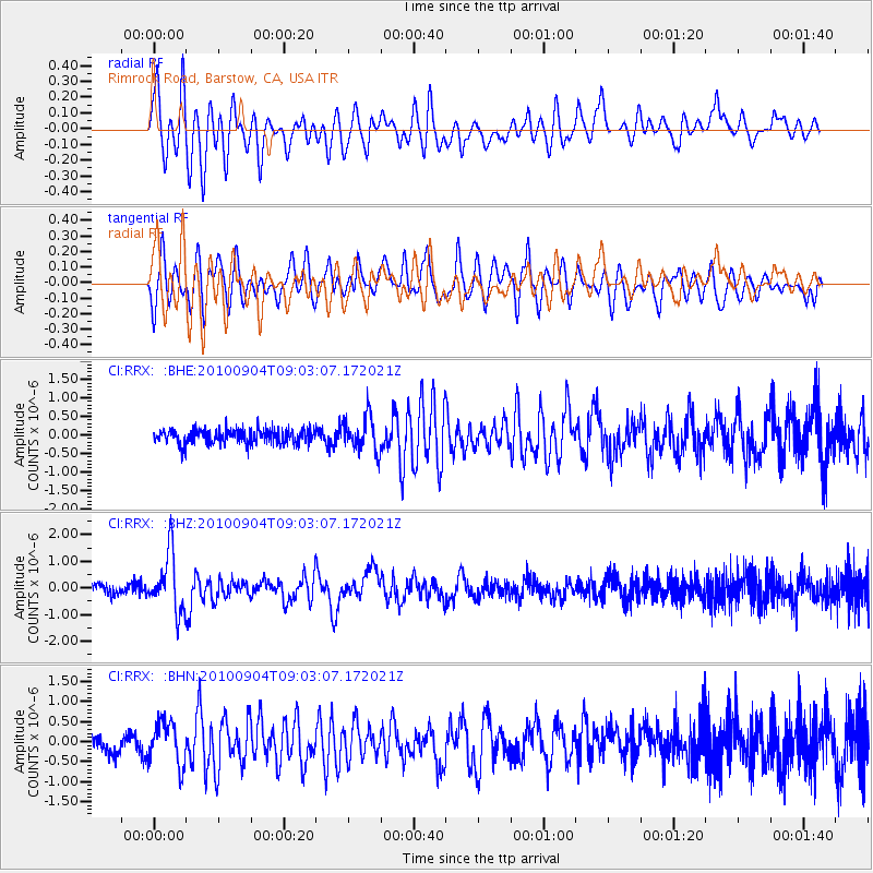
| Radial Match: |
82.20109 % |
| Radial Bump: |
400 |
| Transverse Match: |
77.13062 % |
| Transverse Bump: |
400 |
| SOD ConfigId: |
319893 |
| Insert Time: |
2011-01-13 07:55:08.146 +0000 |
| GWidth: |
2.5 |
| Max Bumps: |
400 |
| Tol: |
0.001 |
|
Signal To Noise
| Channel | StoN | STA | LTA |
| CI:RRX: :BHZ:20100904T09:03:07.172021Z | 6.5001426 | 1.0714962E-6 | 1.6484195E-7 |
| CI:RRX: :BHN:20100904T09:03:07.172021Z | 2.7065883 | 5.3530886E-7 | 1.9777994E-7 |
| CI:RRX: :BHE:20100904T09:03:07.172021Z | 2.437911 | 4.748678E-7 | 1.947847E-7 |
| Arrivals |
| Ps | 4.4 SECOND |
| PpPs | 12 SECOND |
| PsPs/PpSs | 17 SECOND |


