You are here: Home > Network List > IU - Global Seismograph Network (GSN - IRIS/USGS) Stations List
> Station SLBS Sierra la Laguna Baja California Sur, Mexico > Earthquake Result Viewer
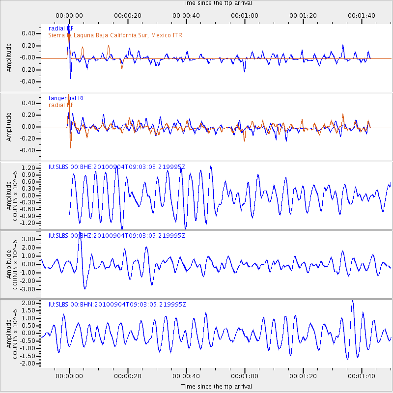
SLBS Sierra la Laguna Baja California Sur, Mexico - Earthquake Result Viewer
*The percent match for this event was below the threshold and hence no stack was calculated.
| Earthquake location: |
Tonga Islands |
| Earthquake latitude/longitude: |
-17.4/-174.0 |
| Earthquake time(UTC): |
2010/09/04 (247) 08:52:04 GMT |
| Earthquake Depth: |
69 km |
| Earthquake Magnitude: |
5.9 MB, 6.1 MW, 6.0 MW |
| Earthquake Catalog/Contributor: |
WHDF/NEIC |
|
| Network: |
IU Global Seismograph Network (GSN - IRIS/USGS) |
| Station: |
SLBS Sierra la Laguna Baja California Sur, Mexico |
| Lat/Lon: |
23.69 N/109.94 W |
| Elevation: |
825 m |
|
| Distance: |
74.7 deg |
| Az: |
58.738 deg |
| Baz: |
242.929 deg |
| Ray Param: |
$rayparam |
*The percent match for this event was below the threshold and hence was not used in the summary stack. |
|
| Radial Match: |
53.9052 % |
| Radial Bump: |
400 |
| Transverse Match: |
56.857723 % |
| Transverse Bump: |
400 |
| SOD ConfigId: |
319893 |
| Insert Time: |
2011-01-13 07:57:40.063 +0000 |
| GWidth: |
2.5 |
| Max Bumps: |
400 |
| Tol: |
0.001 |
|
Signal To Noise
| Channel | StoN | STA | LTA |
| IU:SLBS:00:BHZ:20100904T09:03:05.219995Z | 3.1853244 | 1.5897089E-6 | 4.990728E-7 |
| IU:SLBS:00:BHN:20100904T09:03:05.219995Z | 1.2094489 | 5.216066E-7 | 4.3127622E-7 |
| IU:SLBS:00:BHE:20100904T09:03:05.219995Z | 0.8322286 | 5.9112585E-7 | 7.102926E-7 |
| Arrivals |
| Ps | |
| PpPs | |
| PsPs/PpSs | |


