You are here: Home > Network List > IW - Intermountain West Stations List
> Station MOOW Moose Ponds, Wyoming, USA > Earthquake Result Viewer
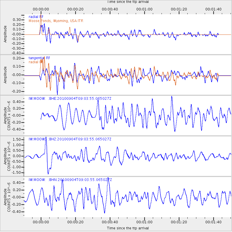
MOOW Moose Ponds, Wyoming, USA - Earthquake Result Viewer
*The percent match for this event was below the threshold and hence no stack was calculated.
| Earthquake location: |
Tonga Islands |
| Earthquake latitude/longitude: |
-17.4/-174.0 |
| Earthquake time(UTC): |
2010/09/04 (247) 08:52:04 GMT |
| Earthquake Depth: |
69 km |
| Earthquake Magnitude: |
5.9 MB, 6.1 MW, 6.0 MW |
| Earthquake Catalog/Contributor: |
WHDF/NEIC |
|
| Network: |
IW Intermountain West |
| Station: |
MOOW Moose Ponds, Wyoming, USA |
| Lat/Lon: |
43.75 N/110.74 W |
| Elevation: |
2128 m |
|
| Distance: |
83.9 deg |
| Az: |
40.61 deg |
| Baz: |
239.063 deg |
| Ray Param: |
$rayparam |
*The percent match for this event was below the threshold and hence was not used in the summary stack. |
|
| Radial Match: |
65.27787 % |
| Radial Bump: |
400 |
| Transverse Match: |
61.21116 % |
| Transverse Bump: |
400 |
| SOD ConfigId: |
319893 |
| Insert Time: |
2011-01-13 07:58:14.503 +0000 |
| GWidth: |
2.5 |
| Max Bumps: |
400 |
| Tol: |
0.001 |
|
Signal To Noise
| Channel | StoN | STA | LTA |
| IW:MOOW: :BHZ:20100904T09:03:55.065027Z | 6.6334667 | 8.6977246E-7 | 1.3111884E-7 |
| IW:MOOW: :BHN:20100904T09:03:55.065027Z | 1.1053774 | 1.529629E-7 | 1.3838068E-7 |
| IW:MOOW: :BHE:20100904T09:03:55.065027Z | 1.0310525 | 1.7365984E-7 | 1.6842968E-7 |
| Arrivals |
| Ps | |
| PpPs | |
| PsPs/PpSs | |


