You are here: Home > Network List > AZ - ANZA Regional Network Stations List
> Station CPE Camp Elliot, Miramar, CA, USA > Earthquake Result Viewer
CPE Camp Elliot, Miramar, CA, USA - Earthquake Result Viewer
| Earthquake location: |
Off East Coast Of Honshu, Japan |
| Earthquake latitude/longitude: |
36.5/142.4 |
| Earthquake time(UTC): |
2008/12/20 (355) 10:29:23 GMT |
| Earthquake Depth: |
19 km |
| Earthquake Magnitude: |
6.0 MB, 6.3 MS, 6.3 MW, 6.3 MW |
| Earthquake Catalog/Contributor: |
WHDF/NEIC |
|
| Network: |
AZ ANZA Regional Network |
| Station: |
CPE Camp Elliot, Miramar, CA, USA |
| Lat/Lon: |
32.89 N/117.11 W |
| Elevation: |
150 m |
|
| Distance: |
78.6 deg |
| Az: |
57.56 deg |
| Baz: |
306.118 deg |
| Ray Param: |
0.049498573 |
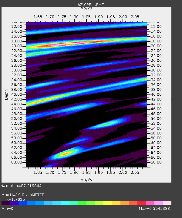
| Estimated Moho Depth: |
19.0 km |
| Estimated Crust Vp/Vs: |
1.76 |
| Assumed Crust Vp: |
6.264 km/s |
| Estimated Crust Vs: |
3.554 km/s |
| Estimated Crust Poisson's Ratio: |
0.26 |
|
| Radial Match: |
87.219864 % |
| Radial Bump: |
347 |
| Transverse Match: |
71.70784 % |
| Transverse Bump: |
400 |
| SOD ConfigId: |
2658 |
| Insert Time: |
2010-02-26 18:53:55.052 +0000 |
| GWidth: |
2.5 |
| Max Bumps: |
400 |
| Tol: |
0.001 |
|

Signal To Noise
| Channel | StoN | STA | LTA |
| AZ:CPE: :BHZ:20081220T10:40:52.219019Z | 8.41397 | 6.5518134E-7 | 7.786828E-8 |
| AZ:CPE: :BHN:20081220T10:40:52.219019Z | 3.6483963 | 2.8677547E-7 | 7.860316E-8 |
| AZ:CPE: :BHE:20081220T10:40:52.219019Z | 1.6631353 | 1.5530586E-7 | 9.3381374E-8 |
| Arrivals |
| Ps | 2.4 SECOND |
| PpPs | 8.1 SECOND |
| PsPs/PpSs | 11 SECOND |


