You are here: Home > Network List > TA - USArray Transportable Network (new EarthScope stations) Stations List
> Station MDND Maddock, ND, USA > Earthquake Result Viewer
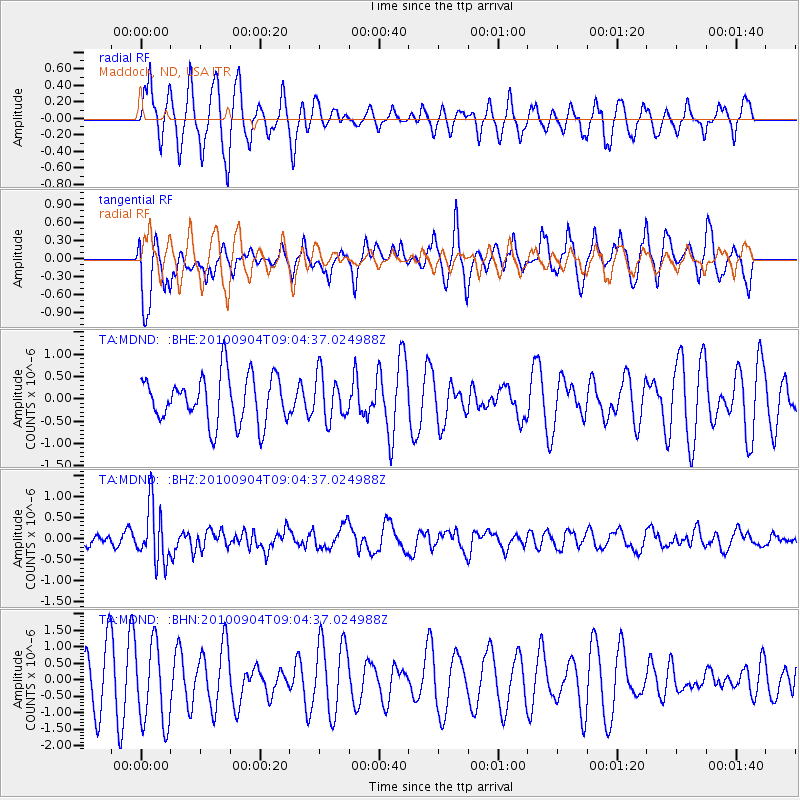
MDND Maddock, ND, USA - Earthquake Result Viewer
*The percent match for this event was below the threshold and hence no stack was calculated.
| Earthquake location: |
Tonga Islands |
| Earthquake latitude/longitude: |
-17.4/-174.0 |
| Earthquake time(UTC): |
2010/09/04 (247) 08:52:04 GMT |
| Earthquake Depth: |
69 km |
| Earthquake Magnitude: |
5.9 MB, 6.1 MW, 6.0 MW |
| Earthquake Catalog/Contributor: |
WHDF/NEIC |
|
| Network: |
TA USArray Transportable Network (new EarthScope stations) |
| Station: |
MDND Maddock, ND, USA |
| Lat/Lon: |
47.85 N/99.60 W |
| Elevation: |
479 m |
|
| Distance: |
92.7 deg |
| Az: |
40.5 deg |
| Baz: |
247.038 deg |
| Ray Param: |
$rayparam |
*The percent match for this event was below the threshold and hence was not used in the summary stack. |
|
| Radial Match: |
63.28922 % |
| Radial Bump: |
373 |
| Transverse Match: |
48.944847 % |
| Transverse Bump: |
370 |
| SOD ConfigId: |
319893 |
| Insert Time: |
2011-01-13 08:02:02.199 +0000 |
| GWidth: |
2.5 |
| Max Bumps: |
400 |
| Tol: |
0.001 |
|
Signal To Noise
| Channel | StoN | STA | LTA |
| TA:MDND: :BHZ:20100904T09:04:37.024988Z | 3.370059 | 6.681209E-7 | 1.9825198E-7 |
| TA:MDND: :BHN:20100904T09:04:37.024988Z | 1.2607112 | 1.2256168E-6 | 9.72163E-7 |
| TA:MDND: :BHE:20100904T09:04:37.024988Z | 0.95018995 | 5.038406E-7 | 5.302525E-7 |
| Arrivals |
| Ps | |
| PpPs | |
| PsPs/PpSs | |


