You are here: Home > Network List > IU - Global Seismograph Network (GSN - IRIS/USGS) Stations List
> Station PMG Port Moresby, New Guinea > Earthquake Result Viewer
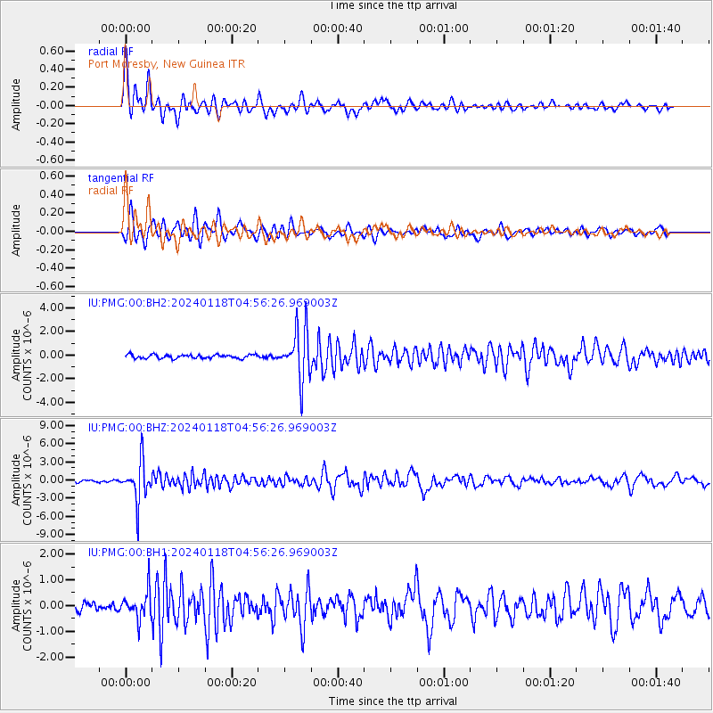
PMG Port Moresby, New Guinea - Earthquake Result Viewer
*The percent match for this event was below the threshold and hence no stack was calculated.
| Earthquake location: |
Fiji Islands Region |
| Earthquake latitude/longitude: |
-21.7/-176.3 |
| Earthquake time(UTC): |
2024/01/18 (018) 04:50:01 GMT |
| Earthquake Depth: |
155 km |
| Earthquake Magnitude: |
5.8 mww |
| Earthquake Catalog/Contributor: |
NEIC PDE/us |
|
| Network: |
IU Global Seismograph Network (GSN - IRIS/USGS) |
| Station: |
PMG Port Moresby, New Guinea |
| Lat/Lon: |
9.40 S/147.16 E |
| Elevation: |
90 m |
|
| Distance: |
37.2 deg |
| Az: |
283.352 deg |
| Baz: |
113.463 deg |
| Ray Param: |
$rayparam |
*The percent match for this event was below the threshold and hence was not used in the summary stack. |
|
| Radial Match: |
86.706665 % |
| Radial Bump: |
400 |
| Transverse Match: |
79.97228 % |
| Transverse Bump: |
400 |
| SOD ConfigId: |
33437571 |
| Insert Time: |
2024-02-01 05:03:51.303 +0000 |
| GWidth: |
2.5 |
| Max Bumps: |
400 |
| Tol: |
0.001 |
|
Signal To Noise
| Channel | StoN | STA | LTA |
| IU:PMG:00:BHZ:20240118T04:56:26.969003Z | 15.767237 | 3.3502918E-6 | 2.1248438E-7 |
| IU:PMG:00:BH1:20240118T04:56:26.969003Z | 2.1079726 | 5.424027E-7 | 2.5731012E-7 |
| IU:PMG:00:BH2:20240118T04:56:26.969003Z | 13.4684 | 2.1226085E-6 | 1.5759916E-7 |
| Arrivals |
| Ps | |
| PpPs | |
| PsPs/PpSs | |


